Weidenhahn geodata
Weidenhahn (Rheinland-Pfalz) is a seat of a fourth-order administrative division; located in Germany in Europe/Berlin (GMT+2) time zone. With population of 542 people, there are 9130 cities with bigger population in this country. Compared to other cities in Germany, 51.8% of cities are located further ↑North; 80.2% of cities are located further →East and 74.6% of cities have lower elevation than Weidenhahn. Note1


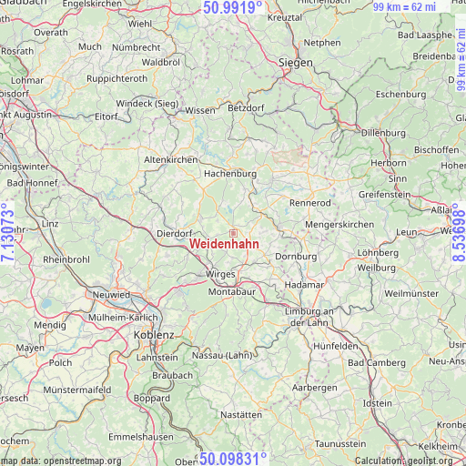
Weidenhahn GPS coordinates[2]
50° 32' 49.992" North, 7° 50' 1.896" East
| Map corner | latitude | longitude |
|---|---|---|
| Upper-left | 50.9919°, | 7.13073° |
| Center: | 50.54722°, | 7.83386° |
| Lower-right: | 50.09831°, | 8.53698° |
| Map W x H: | 99.4×99.4 km | = 61.8×61.8mi |
| max Lat: | 55.01917° ⇑51.8% North |
| Weidenhahn: | 50.54722° |
| min Lat: | ⇓48.2% South 47.40724° |
| min Long | Weidenhahn | max Long |
| 5.92978° | 7.83386° | 14.98853° |
| W 19.8%⇐ | ⇒80.2% E |
Elevation
Elevation of Weidenhahn is 394 m = 1293 ft, and this is 144.9 m = 475 ft above average elevation for this country.
| Max E: |
1256 m = 4121 ft | 25.4% |
| Weidenhahn | 394 m 1293 ft | |
| Avg. | 249.1 m = 817 ft | |
Min E: |
-5 m = -16 ft | 74.6% |
See also: Germany elevation on elevation.city.
Geographical zone
Weidenhahn is located in North temperate zone (between Tropic of Cancer and the Arctic Circle). Distance of this North polar circle is 1780.9 km =1106.6 mi to North.| Distance of | km | miles | from Weidenhahn |
|---|---|---|---|
| North Pole | 4386.7 | 2725.8 | to North |
| Arctic Circle | 1780.9 | 1106.6 | to North |
| Tropic Cancer | 3014.4 | 1873.1 | to South |
| Equator | 5620.3 | 3492.3 | to South |


Nearby cities:
15 places around Weidenhahn: (largest is in red/bold)
• Arnshöfen
2.7 km =1.7 mi,  106°
106°
• Dreifelden
4.9 km =3 mi,  1°
1°
• Ettinghausen
4.4 km =2.7 mi,  142°
142°
• Ewighausen
1.4 km =0.9 mi,  197°
197°
• Freilingen
1.3 km =0.8 mi, 2°
• Hartenfels
4.4 km =2.7 mi,  311°
311°
• Helferskirchen
4.4 km =2.7 mi, 200°
• Kuhnhöfen
2.6 km =1.6 mi,  126°
126°
• Maxsain
3.5 km =2.2 mi,  262°
262°
• Niedersayn
2.1 km =1.3 mi,  184°
184°
• Quirnbach
3.9 km =2.4 mi,  221°
221°
• Rothenbach
5.3 km =3.3 mi,  68°
68°
• Steinen
4.7 km =2.9 mi,  329°
329°
• Wölferlingen
2.3 km =1.4 mi,  32°
32°
• Ötzingen
5.3 km =3.3 mi, 180°
Sources, notices
• [Note1] Compared only with cities in Germany existing in our database
• [Src1] Map data: © OpenStreetMap contributors (CC-BY-SA)
• [Src2] Other city data from geonames.org with taken over terms of usage.
• [Src3] Geographical zone / Annual Mean Temperature by Robert A. Rohde @ Wikipedia
