Wölferlingen geodata
Wölferlingen (Rheinland-Pfalz) is a seat of a fourth-order administrative division; located in Germany in Europe/Berlin (GMT+2) time zone. With population of 569 people, there are 8979 cities with bigger population in this country. Compared to other cities in Germany, 51.4% of cities are located further ↑North; 80% of cities are located further →East and 75.8% of cities have lower elevation than Wölferlingen. Note1


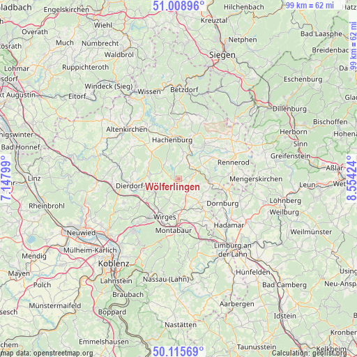
Wölferlingen GPS coordinates[2]
50° 33' 51.984" North, 7° 51' 3.996" East
| Map corner | latitude | longitude |
|---|---|---|
| Upper-left | 51.00896°, | 7.14799° |
| Center: | 50.56444°, | 7.85111° |
| Lower-right: | 50.11569°, | 8.55424° |
| Map W x H: | 99.3×99.3 km | = 61.7×61.7mi |
| max Lat: | 55.01917° ⇑51.4% North |
| Wölferlingen: | 50.56444° |
| min Lat: | ⇓48.6% South 47.40724° |
| min Long | Wölferlingen | max Long |
| 5.92978° | 7.85111° | 14.98853° |
| W 20%⇐ | ⇒80% E |
Elevation
Elevation of Wölferlingen is 404 m = 1325 ft, and this is 154.9 m = 508 ft above average elevation for this country.
| Max E: |
1256 m = 4121 ft | 24.2% |
| Wölferlingen | 404 m 1325 ft | |
| Avg. | 249.1 m = 817 ft | |
Min E: |
-5 m = -16 ft | 75.8% |
See also: Germany elevation on elevation.city.
Geographical zone
Wölferlingen is located in North temperate zone (between Tropic of Cancer and the Arctic Circle). Distance of this North polar circle is 1778.9 km =1105.4 mi to North.| Distance of | km | miles | from Wölferlingen |
|---|---|---|---|
| North Pole | 4384.8 | 2724.6 | to North |
| Arctic Circle | 1778.9 | 1105.4 | to North |
| Tropic Cancer | 3016.3 | 1874.2 | to South |
| Equator | 5622.2 | 3493.5 | to South |


Nearby cities:
15 places around Wölferlingen: (largest is in red/bold)
• Arnshöfen
3 km =1.9 mi,  153°
153°
• Brandscheid
4.9 km =3 mi,  94°
94°
• Dreifelden
3.2 km =2 mi,  340°
340°
• Ewighausen
3.7 km =2.3 mi,  206°
206°
• Freilingen
1.3 km =0.8 mi,  243°
243°
• Hartenfels
4.6 km =2.9 mi,  283°
283°
• Kaden
4.9 km =3 mi,  111°
111°
• Kuhnhöfen
3.6 km =2.2 mi,  166°
166°
• Linden
4 km =2.5 mi,  358°
358°
• Lochum
4.7 km =2.9 mi,  12°
12°
• Niedersayn
4.2 km =2.6 mi,  199°
199°
• Rotenhain
4.6 km =2.9 mi,  29°
29°
• Rothenbach
3.7 km =2.3 mi, 90°
• Steinen
4.2 km =2.6 mi,  300°
300°
• Weidenhahn
2.3 km =1.4 mi, 212°
Sources, notices
• [Note1] Compared only with cities in Germany existing in our database
• [Src1] Map data: © OpenStreetMap contributors (CC-BY-SA)
• [Src2] Other city data from geonames.org with taken over terms of usage.
• [Src3] Geographical zone / Annual Mean Temperature by Robert A. Rohde @ Wikipedia
