Hartenfels geodata
Hartenfels (Rheinland-Pfalz) is a seat of a fourth-order administrative division; located in Germany in Europe/Berlin (GMT+2) time zone. With population of 871 people, there are 7623 cities with bigger population in this country. Compared to other cities in Germany, 51.2% of cities are located further ↑North; 81.1% of cities are located further →East and 70.5% of cities have lower elevation than Hartenfels. Note1


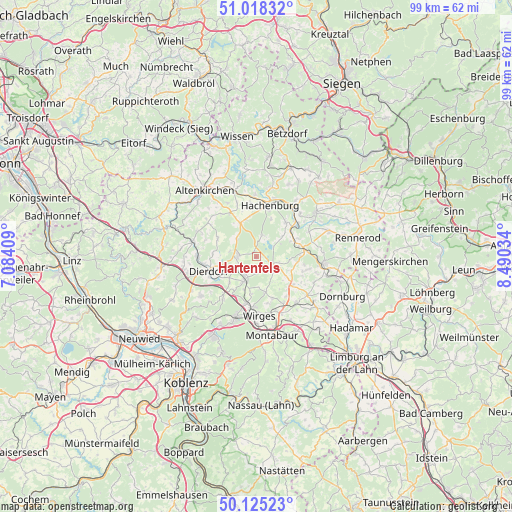
Hartenfels GPS coordinates[2]
50° 34' 26.004" North, 7° 47' 13.992" East
| Map corner | latitude | longitude |
|---|---|---|
| Upper-left | 51.01832°, | 7.08409° |
| Center: | 50.57389°, | 7.78722° |
| Lower-right: | 50.12523°, | 8.49034° |
| Map W x H: | 99.3×99.3 km | = 61.7×61.7mi |
| max Lat: | 55.01917° ⇑51.2% North |
| Hartenfels: | 50.57389° |
| min Lat: | ⇓48.8% South 47.40724° |
| min Long | Hartenfels | max Long |
| 5.92978° | 7.78722° | 14.98853° |
| W 18.9%⇐ | ⇒81.1% E |
Elevation
Elevation of Hartenfels is 362 m = 1188 ft, and this is 112.9 m = 370 ft above average elevation for this country.
| Max E: |
1256 m = 4121 ft | 29.5% |
| Hartenfels | 362 m 1188 ft | |
| Avg. | 249.1 m = 817 ft | |
Min E: |
-5 m = -16 ft | 70.5% |
See also: Germany elevation on elevation.city.
Geographical zone
Hartenfels is located in North temperate zone (between Tropic of Cancer and the Arctic Circle). Distance of this North polar circle is 1777.9 km =1104.7 mi to North.| Distance of | km | miles | from Hartenfels |
|---|---|---|---|
| North Pole | 4383.8 | 2724 | to North |
| Arctic Circle | 1777.9 | 1104.7 | to North |
| Tropic Cancer | 3017.4 | 1874.9 | to South |
| Equator | 5623.3 | 3494.2 | to South |


Nearby cities:
15 places around Hartenfels: (largest is in red/bold)
• Dreifelden
4 km =2.5 mi,  60°
60°
• Ewighausen
5.2 km =3.2 mi,  146°
146°
• Freilingen
3.7 km =2.3 mi,  115°
115°
• Freirachdorf
5.1 km =3.2 mi,  281°
281°
• Goddert
4 km =2.5 mi,  225°
225°
• Herschbach
3.9 km =2.4 mi,  285°
285°
• Maxsain
3.4 km =2.1 mi,  182°
182°
• Mündersbach
5.2 km =3.2 mi,  313°
313°
• Rückeroth
3.3 km =2.1 mi,  245°
245°
• Schenkelberg
1.1 km =0.7 mi,  343°
343°
• Selters
5.1 km =3.2 mi,  205°
205°
• Steinebach
4.2 km =2.6 mi,  18°
18°
• Steinen
1.4 km =0.9 mi,  40°
40°
• Weidenhahn
4.4 km =2.7 mi,  131°
131°
• Wölferlingen
4.6 km =2.9 mi,  103°
103°
Sources, notices
• [Note1] Compared only with cities in Germany existing in our database
• [Src1] Map data: © OpenStreetMap contributors (CC-BY-SA)
• [Src2] Other city data from geonames.org with taken over terms of usage.
• [Src3] Geographical zone / Annual Mean Temperature by Robert A. Rohde @ Wikipedia
