Ewighausen geodata
Ewighausen (Rheinland-Pfalz) is a seat of a fourth-order administrative division; located in Germany in Europe/Berlin (GMT+2) time zone. With population of 244 people, there are 10287 cities with bigger population in this country. Compared to other cities in Germany, 52% of cities are located further ↑North; 80.5% of cities are located further →East and 73.9% of cities have lower elevation than Ewighausen. Note1


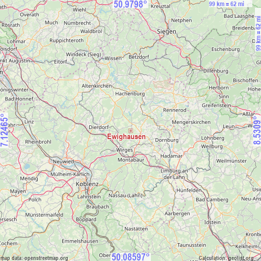
Ewighausen GPS coordinates[2]
50° 32' 6" North, 7° 49' 40.008" East
| Map corner | latitude | longitude |
|---|---|---|
| Upper-left | 50.9798°, | 7.12465° |
| Center: | 50.535°, | 7.82778° |
| Lower-right: | 50.08597°, | 8.5309° |
| Map W x H: | 99.4×99.4 km | = 61.8×61.8mi |
| max Lat: | 55.01917° ⇑52% North |
| Ewighausen: | 50.535° |
| min Lat: | ⇓48% South 47.40724° |
| min Long | Ewighausen | max Long |
| 5.92978° | 7.82778° | 14.98853° |
| W 19.5%⇐ | ⇒80.5% E |
Elevation
Elevation of Ewighausen is 389 m = 1276 ft, and this is 139.9 m = 459 ft above average elevation for this country.
| Max E: |
1256 m = 4121 ft | 26.1% |
| Ewighausen | 389 m 1276 ft | |
| Avg. | 249.1 m = 817 ft | |
Min E: |
-5 m = -16 ft | 73.9% |
See also: Germany elevation on elevation.city.
Geographical zone
Ewighausen is located in North temperate zone (between Tropic of Cancer and the Arctic Circle). Distance of this North polar circle is 1782.2 km =1107.4 mi to North.| Distance of | km | miles | from Ewighausen |
|---|---|---|---|
| North Pole | 4388.1 | 2726.6 | to North |
| Arctic Circle | 1782.2 | 1107.4 | to North |
| Tropic Cancer | 3013 | 1872.2 | to South |
| Equator | 5619 | 3491.5 | to South |


Nearby cities:
15 places around Ewighausen: (largest is in red/bold)
• Arnshöfen
3 km =1.9 mi,  78°
78°
• Ettinghausen
3.8 km =2.4 mi,  124°
124°
• Freilingen
2.7 km =1.7 mi,  10°
10°
• Helferskirchen
3 km =1.9 mi,  202°
202°
• Kuhnhöfen
2.5 km =1.6 mi,  94°
94°
• Leuterod
4.4 km =2.7 mi,  188°
188°
• Maxsain
3.1 km =1.9 mi,  286°
286°
• Niedersayn
0.8 km =0.5 mi,  158°
158°
• Oberahr
4.8 km =3 mi,  144°
144°
• Quirnbach
2.7 km =1.7 mi,  234°
234°
• Selters
5.1 km =3.2 mi,  266°
266°
• Vielbach
4.8 km =3 mi,  235°
235°
• Weidenhahn
1.4 km =0.9 mi,  17°
17°
• Wölferlingen
3.7 km =2.3 mi,  26°
26°
• Ötzingen
3.9 km =2.4 mi,  174°
174°
Sources, notices
• [Note1] Compared only with cities in Germany existing in our database
• [Src1] Map data: © OpenStreetMap contributors (CC-BY-SA)
• [Src2] Other city data from geonames.org with taken over terms of usage.
• [Src3] Geographical zone / Annual Mean Temperature by Robert A. Rohde @ Wikipedia
