Weiden geodata
Weiden (Bavaria) is a seat of a third-order administrative division; located in Germany in Europe/Berlin (GMT+1) time zone. With population of 42,550 people, there are 292 cities with bigger population in this country. Compared to other cities in Germany, 71.9% of cities are located further ↑North; 83.9% of cities are located further ←West and 74.9% of cities have lower elevation than Weiden. Note1
Administrative division(s):
- Level 1: Bavaria
- Level 2: Upper Palatinate
- Level 3: Kreisfreie Stadt Weiden in der Oberpfalz
- Level 4: Weiden i.d.OPf.


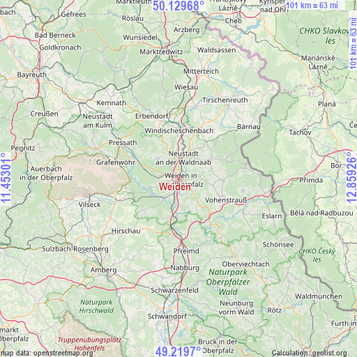
Weiden GPS coordinates[2]
49° 40' 36.552" North, 12° 9' 22.068" East
| Map corner | latitude | longitude |
|---|---|---|
| Upper-left | 50.12968°, | 11.45301° |
| Center: | 49.67682°, | 12.15613° |
| Lower-right: | 49.2197°, | 12.85926° |
| Map W x H: | 101.2×101.2 km | = 62.9×62.9mi |
| max Lat: | 55.01917° ⇑71.9% North |
| Weiden: | 49.67682° |
| min Lat: | ⇓28.1% South 47.40724° |
| min Long | Weiden | max Long |
| 5.92978° | 12.15613° | 14.98853° |
| W 83.9%⇐ | ⇒16.1% E |
Elevation
Elevation of Weiden is 397 m = 1302 ft, and this is 147.9 m = 485 ft above average elevation for this country.
| Max E: |
1256 m = 4121 ft | 25.1% |
| Weiden | 397 m 1302 ft | |
| Avg. | 249.1 m = 817 ft | |
Min E: |
-5 m = -16 ft | 74.9% |
See also: Weiden elevation on elevation.city.
Geographical zone
Weiden is located in North temperate zone (between Tropic of Cancer and the Arctic Circle). Distance of this North polar circle is 1877.6 km =1166.7 mi to North.| Distance of | km | miles | from Weiden |
|---|---|---|---|
| North Pole | 4483.5 | 2785.9 | to North |
| Arctic Circle | 1877.6 | 1166.7 | to North |
| Tropic Cancer | 2917.6 | 1812.9 | to South |
| Equator | 5523.5 | 3432.1 | to South |


Nearby cities:
15 places around Weiden: (largest is in red/bold)
• Bechtsrieth
5.3 km =3.3 mi,  132°
132°
• Etzenricht
6.3 km =3.9 mi,  219°
219°
• Floß
10.1 km =6.3 mi,  58°
58°
• Irchenrieth
7.8 km =4.8 mi,  140°
140°
• Leuchtenberg
11.5 km =7.1 mi, 140°
• Luhe-Wildenau
10.4 km =6.5 mi,  182°
182°
• Mantel
8.7 km =5.4 mi,  253°
253°
• Neustadt an der Waldnaab
6.4 km =4 mi,  13°
13°
• Parkstein
8.6 km =5.3 mi,  312°
312°
• Pirk
4.9 km =3 mi,  171°
171°
• Püchersreuth
9.8 km =6.1 mi,  34°
34°
• Schirmitz
3.1 km =1.9 mi, 165°
• Störnstein
7.1 km =4.4 mi, 29°
• Theisseil
5.3 km =3.3 mi,  73°
73°
• Weiherhammer
8.1 km =5 mi,  233°
233°
Sources, notices
• [Note1] Compared only with cities in Germany existing in our database
• [Src1] Map data: © OpenStreetMap contributors (CC-BY-SA)
• [Src2] Other city data from geonames.org with taken over terms of usage.
• [Src3] Geographical zone / Annual Mean Temperature by Robert A. Rohde @ Wikipedia
