Störnstein geodata
Störnstein (Bavaria) is a seat of a fourth-order administrative division; located in Germany in Europe/Berlin (GMT+2) time zone. With population of 1,445 people, there are 5987 cities with bigger population in this country. Compared to other cities in Germany, 70.6% of cities are located further ↑North; 84.8% of cities are located further ←West and 81.3% of cities have lower elevation than Störnstein. Note1
Administrative division(s):
- Level 1: Bavaria
- Level 2: Upper Palatinate
- Level 3: Landkreis Neustadt an der Waldnaab
- Level 4: Störnstein


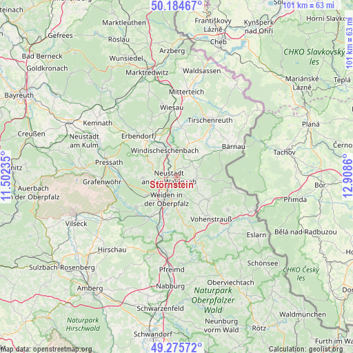
Störnstein GPS coordinates[2]
49° 43' 56.352" North, 12° 12' 19.692" East
| Map corner | latitude | longitude |
|---|---|---|
| Upper-left | 50.18467°, | 11.50235° |
| Center: | 49.73232°, | 12.20547° |
| Lower-right: | 49.27572°, | 12.9086° |
| Map W x H: | 101.1×101.1 km | = 62.8×62.8mi |
| max Lat: | 55.01917° ⇑70.6% North |
| Störnstein: | 49.73232° |
| min Lat: | ⇓29.4% South 47.40724° |
| min Long | Störnstein | max Long |
| 5.92978° | 12.20547° | 14.98853° |
| W 84.8%⇐ | ⇒15.2% E |
Elevation
Elevation of Störnstein is 442 m = 1450 ft, and this is 192.9 m = 633 ft above average elevation for this country.
| Max E: |
1256 m = 4121 ft | 18.7% |
| Störnstein | 442 m 1450 ft | |
| Avg. | 249.1 m = 817 ft | |
Min E: |
-5 m = -16 ft | 81.3% |
See also: Germany elevation on elevation.city.
Geographical zone
Störnstein is located in North temperate zone (between Tropic of Cancer and the Arctic Circle). Distance of this North polar circle is 1871.5 km =1162.9 mi to North.| Distance of | km | miles | from Störnstein |
|---|---|---|---|
| North Pole | 4477.3 | 2782.1 | to North |
| Arctic Circle | 1871.5 | 1162.9 | to North |
| Tropic Cancer | 2923.8 | 1816.8 | to South |
| Equator | 5529.7 | 3436 | to South |


Nearby cities:
15 places around Störnstein: (largest is in red/bold)
• Bechtsrieth
9.7 km =6 mi,  178°
178°
• Berg
10.2 km =6.3 mi,  333°
333°
• Flossenbürg
10.4 km =6.5 mi,  89°
89°
• Floß
5.1 km =3.2 mi,  100°
100°
• Kirchendemenreuth
9.5 km =5.9 mi,  306°
306°
• Konradsreuth
6.6 km =4.1 mi,  80°
80°
• Neustadt an der Waldnaab
2 km =1.2 mi,  271°
271°
• Parkstein
9.9 km =6.2 mi, 268°
• Pirk
11.4 km =7.1 mi,  194°
194°
• Püchersreuth
2.8 km =1.7 mi,  45°
45°
• Schirmitz
9.6 km =6 mi,  196°
196°
• Theisseil
4.9 km =3 mi,  161°
161°
• Waldthurn
11.1 km =6.9 mi,  126°
126°
• Weiden
7.1 km =4.4 mi,  209°
209°
• Windischeschenbach
8.4 km =5.2 mi,  335°
335°
Sources, notices
• [Note1] Compared only with cities in Germany existing in our database
• [Src1] Map data: © OpenStreetMap contributors (CC-BY-SA)
• [Src2] Other city data from geonames.org with taken over terms of usage.
• [Src3] Geographical zone / Annual Mean Temperature by Robert A. Rohde @ Wikipedia
