Wittelshofen geodata
Wittelshofen (Bavaria) is a seat of a fourth-order administrative division; located in Germany in Europe/Berlin (GMT+2) time zone. With population of 1,274 people, there are 6381 cities with bigger population in this country. Compared to other cities in Germany, 82.2% of cities are located further ↑North; 58.6% of cities are located further ←West and 79.3% of cities have lower elevation than Wittelshofen. Note1
Administrative division(s):
- Level 1: Bavaria
- Level 2: Regierungsbezirk Mittelfranken
- Level 3: Landkreis Ansbach
- Level 4: Wittelshofen


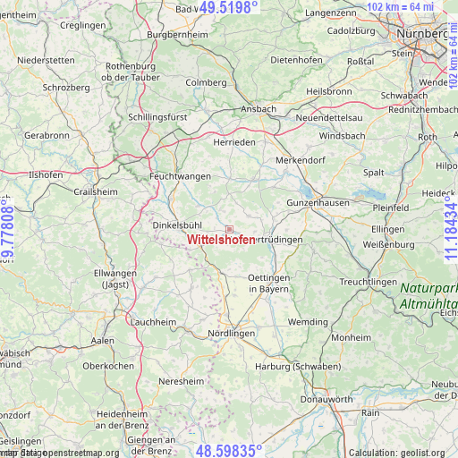
Wittelshofen GPS coordinates[2]
49° 3' 40.356" North, 10° 28' 52.356" East
| Map corner | latitude | longitude |
|---|---|---|
| Upper-left | 49.5198°, | 9.77808° |
| Center: | 49.06121°, | 10.48121° |
| Lower-right: | 48.59835°, | 11.18434° |
| Map W x H: | 102.5×102.5 km | = 63.7×63.7mi |
| max Lat: | 55.01917° ⇑82.2% North |
| Wittelshofen: | 49.06121° |
| min Lat: | ⇓17.8% South 47.40724° |
| min Long | Wittelshofen | max Long |
| 5.92978° | 10.48121° | 14.98853° |
| W 58.6%⇐ | ⇒41.4% E |
Elevation
Elevation of Wittelshofen is 429 m = 1407 ft, and this is 179.9 m = 590 ft above average elevation for this country.
| Max E: |
1256 m = 4121 ft | 20.7% |
| Wittelshofen | 429 m 1407 ft | |
| Avg. | 249.1 m = 817 ft | |
Min E: |
-5 m = -16 ft | 79.3% |
See also: Germany elevation on elevation.city.
Geographical zone
Wittelshofen is located in North temperate zone (between Tropic of Cancer and the Arctic Circle). Distance of this North polar circle is 1946.1 km =1209.3 mi to North.| Distance of | km | miles | from Wittelshofen |
|---|---|---|---|
| North Pole | 4552 | 2828.5 | to North |
| Arctic Circle | 1946.1 | 1209.3 | to North |
| Tropic Cancer | 2849.2 | 1770.4 | to South |
| Equator | 5455.1 | 3389.6 | to South |


Nearby cities:
15 places around Wittelshofen: (largest is in red/bold)
• Burk
8 km =5 mi,  358°
358°
• Dentlein am Forst
10.5 km =6.5 mi,  336°
336°
• Dinkelsbühl
11.8 km =7.3 mi,  274°
274°
• Dürrwangen
8.7 km =5.4 mi,  306°
306°
• Ehingen
5.2 km =3.2 mi,  56°
56°
• Fremdingen
10 km =6.2 mi,  189°
189°
• Gerolfingen
2.4 km =1.5 mi,  111°
111°
• Langfurth
4.9 km =3 mi, 335°
• Mönchsroth
10.1 km =6.3 mi,  242°
242°
• Röckingen
5.7 km =3.5 mi,  96°
96°
• Unterschwaningen
10.4 km =6.5 mi,  78°
78°
• Wassertrüdingen
8.8 km =5.5 mi, 103°
• Weiltingen
3.3 km =2.1 mi,  221°
221°
• Wieseth
11.7 km =7.3 mi,  0°
0°
• Wilburgstetten
7.5 km =4.7 mi, 236°
Sources, notices
• [Note1] Compared only with cities in Germany existing in our database
• [Src1] Map data: © OpenStreetMap contributors (CC-BY-SA)
• [Src2] Other city data from geonames.org with taken over terms of usage.
• [Src3] Geographical zone / Annual Mean Temperature by Robert A. Rohde @ Wikipedia
