Langfurth geodata
Langfurth (Bavaria) is a seat of a fourth-order administrative division; located in Germany in Europe/Berlin (GMT+2) time zone. With population of 2,211 people, there are 4789 cities with bigger population in this country. Compared to other cities in Germany, 81.7% of cities are located further ↑North; 58.2% of cities are located further ←West and 81.7% of cities have lower elevation than Langfurth. Note1
Administrative division(s):
- Level 1: Bavaria
- Level 2: Regierungsbezirk Mittelfranken
- Level 3: Landkreis Ansbach
- Level 4: Langfurth


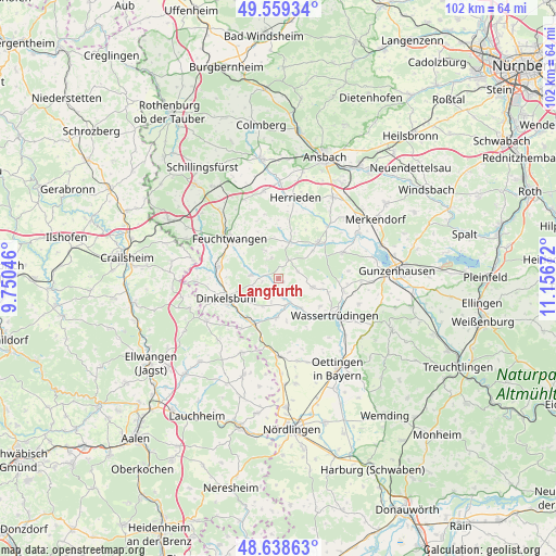
Langfurth GPS coordinates[2]
49° 6' 4.032" North, 10° 27' 12.924" East
| Map corner | latitude | longitude |
|---|---|---|
| Upper-left | 49.55934°, | 9.75046° |
| Center: | 49.10112°, | 10.45359° |
| Lower-right: | 48.63863°, | 11.15672° |
| Map W x H: | 102.4×102.4 km | = 63.6×63.6mi |
| max Lat: | 55.01917° ⇑81.7% North |
| Langfurth: | 49.10112° |
| min Lat: | ⇓18.3% South 47.40724° |
| min Long | Langfurth | max Long |
| 5.92978° | 10.45359° | 14.98853° |
| W 58.2%⇐ | ⇒41.8% E |
Elevation
Elevation of Langfurth is 444 m = 1457 ft, and this is 194.9 m = 639 ft above average elevation for this country.
| Max E: |
1256 m = 4121 ft | 18.3% |
| Langfurth | 444 m 1457 ft | |
| Avg. | 249.1 m = 817 ft | |
Min E: |
-5 m = -16 ft | 81.7% |
See also: Germany elevation on elevation.city.
Geographical zone
Langfurth is located in North temperate zone (between Tropic of Cancer and the Arctic Circle). Distance of this North polar circle is 1941.6 km =1206.5 mi to North.| Distance of | km | miles | from Langfurth |
|---|---|---|---|
| North Pole | 4547.5 | 2825.7 | to North |
| Arctic Circle | 1941.6 | 1206.5 | to North |
| Tropic Cancer | 2853.6 | 1773.1 | to South |
| Equator | 5459.5 | 3392.4 | to South |


Nearby cities:
15 places around Langfurth: (largest is in red/bold)
• Burk
4 km =2.5 mi,  27°
27°
• Dentlein am Forst
5.6 km =3.5 mi,  336°
336°
• Dinkelsbühl
10.4 km =6.5 mi,  250°
250°
• Dürrwangen
5 km =3.1 mi,  278°
278°
• Ehingen
6.5 km =4 mi,  104°
104°
• Feuchtwangen
10.8 km =6.7 mi,  309°
309°
• Gerolfingen
6.8 km =4.2 mi,  141°
141°
• Lichtenau
8.5 km =5.3 mi,  320°
320°
• Mönchsroth
11.5 km =7.1 mi,  217°
217°
• Röckingen
9.2 km =5.7 mi,  123°
123°
• Schopfloch
10.8 km =6.7 mi, 280°
• Weiltingen
6.9 km =4.3 mi,  181°
181°
• Wieseth
7.6 km =4.7 mi,  16°
16°
• Wilburgstetten
9.6 km =6 mi,  206°
206°
• Wittelshofen
4.9 km =3 mi,  155°
155°
Sources, notices
• [Note1] Compared only with cities in Germany existing in our database
• [Src1] Map data: © OpenStreetMap contributors (CC-BY-SA)
• [Src2] Other city data from geonames.org with taken over terms of usage.
• [Src3] Geographical zone / Annual Mean Temperature by Robert A. Rohde @ Wikipedia
