Wasserburg geodata
Wasserburg (Bavaria) is a populated place; located in Germany in Europe/Berlin (GMT+2) time zone. With population of 3,238 people, there are 3799 cities with bigger population in this country. Compared to other cities in Germany, 89.8% of cities are located further ↑North; 54.8% of cities are located further ←West and 83.1% of cities have lower elevation than Wasserburg. Note1
Administrative division(s):
- Level 1: Bavaria
- Level 2: Swabia
- Level 3: Landkreis Günzburg
- Level 4: Günzburg


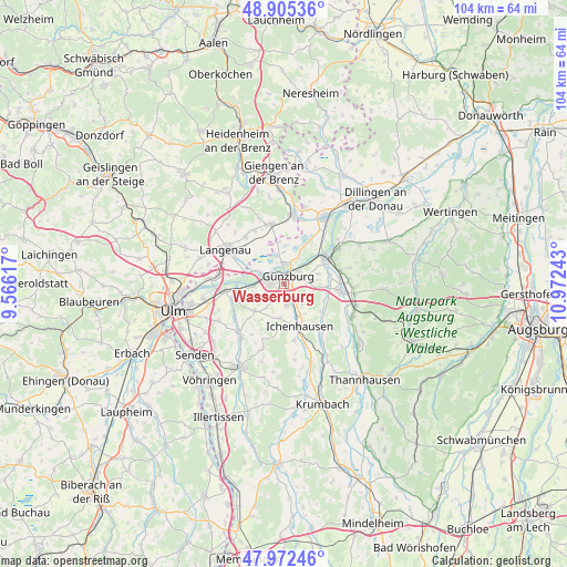
Wasserburg GPS coordinates[2]
48° 26' 27.78" North, 10° 16' 9.48" East
| Map corner | latitude | longitude |
|---|---|---|
| Upper-left | 48.90536°, | 9.56617° |
| Center: | 48.44105°, | 10.2693° |
| Lower-right: | 47.97246°, | 10.97243° |
| Map W x H: | 103.7×103.7 km | = 64.4×64.4mi |
| max Lat: | 55.01917° ⇑89.8% North |
| Wasserburg: | 48.44105° |
| min Lat: | ⇓10.2% South 47.40724° |
| min Long | Wasserburg | max Long |
| 5.92978° | 10.2693° | 14.98853° |
| W 54.8%⇐ | ⇒45.2% E |
Elevation
Elevation of Wasserburg is 454 m = 1490 ft, and this is 204.9 m = 672 ft above average elevation for this country.
| Max E: |
1256 m = 4121 ft | 16.9% |
| Wasserburg | 454 m 1490 ft | |
| Avg. | 249.1 m = 817 ft | |
Min E: |
-5 m = -16 ft | 83.1% |
See also: Germany elevation on elevation.city.
Geographical zone
Wasserburg is located in North temperate zone (between Tropic of Cancer and the Arctic Circle). Distance of this North polar circle is 2015 km =1252.1 mi to North.| Distance of | km | miles | from Wasserburg |
|---|---|---|---|
| North Pole | 4620.9 | 2871.3 | to North |
| Arctic Circle | 2015 | 1252.1 | to North |
| Tropic Cancer | 2780.2 | 1727.5 | to South |
| Equator | 5386.1 | 3346.8 | to South |


Nearby cities:
15 places around Wasserburg: (largest is in red/bold)
• Asselfingen
11.4 km =7.1 mi,  329°
329°
• Bubesheim
1.7 km =1.1 mi,  238°
238°
• Burgau
10.4 km =6.5 mi,  95°
95°
• Ellzee
11.8 km =7.3 mi,  161°
161°
• Gundremmingen
11.7 km =7.3 mi,  55°
55°
• Günzburg
1.8 km =1.1 mi,  18°
18°
• Ichenhausen
8.3 km =5.2 mi, 160°
• Leipheim
3.6 km =2.2 mi,  286°
286°
• Nersingen
10.8 km =6.7 mi,  262°
262°
• Niederstotzingen
11.4 km =7.1 mi,  347°
347°
• Offingen
8.3 km =5.2 mi, 56°
• Rammingen
11.2 km =7 mi,  320°
320°
• Rettenbach
6.4 km =4 mi,  72°
72°
• Rieden an der Kötz
6.3 km =3.9 mi,  188°
188°
• Waldstetten
10.5 km =6.5 mi,  170°
170°
Sources, notices
• [Note1] Compared only with cities in Germany existing in our database
• [Src1] Map data: © OpenStreetMap contributors (CC-BY-SA)
• [Src2] Other city data from geonames.org with taken over terms of usage.
• [Src3] Geographical zone / Annual Mean Temperature by Robert A. Rohde @ Wikipedia
