Nersingen geodata
Nersingen (Bavaria) is a seat of a fourth-order administrative division; located in Germany in Europe/Berlin (GMT+2) time zone. With population of 9,177 people, there are 1756 cities with bigger population in this country. Compared to other cities in Germany, 89.9% of cities are located further ↑North; 52% of cities are located further ←West and 84.1% of cities have lower elevation than Nersingen. Note1
Administrative division(s):
- Level 1: Bavaria
- Level 2: Swabia
- Level 3: Landkreis Neu-Ulm
- Level 4: Nersingen


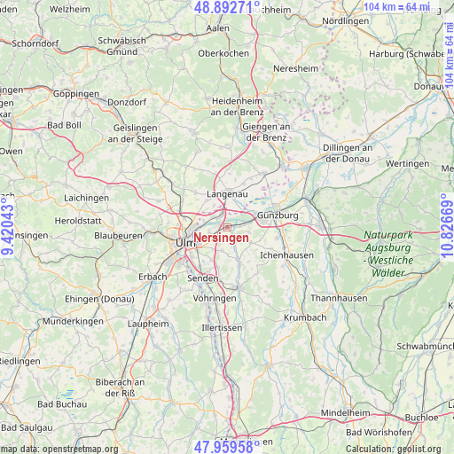
Nersingen GPS coordinates[2]
48° 25' 41.844" North, 10° 7' 24.816" East
| Map corner | latitude | longitude |
|---|---|---|
| Upper-left | 48.89271°, | 9.42043° |
| Center: | 48.42829°, | 10.12356° |
| Lower-right: | 47.95958°, | 10.82669° |
| Map W x H: | 103.8×103.8 km | = 64.5×64.5mi |
| max Lat: | 55.01917° ⇑89.9% North |
| Nersingen: | 48.42829° |
| min Lat: | ⇓10.1% South 47.40724° |
| min Long | Nersingen | max Long |
| 5.92978° | 10.12356° | 14.98853° |
| W 52%⇐ | ⇒48% E |
Elevation
Elevation of Nersingen is 462 m = 1516 ft, and this is 212.9 m = 698 ft above average elevation for this country.
| Max E: |
1256 m = 4121 ft | 15.9% |
| Nersingen | 462 m 1516 ft | |
| Avg. | 249.1 m = 817 ft | |
Min E: |
-5 m = -16 ft | 84.1% |
See also: Germany elevation on elevation.city.
Geographical zone
Nersingen is located in North temperate zone (between Tropic of Cancer and the Arctic Circle). Distance of this North polar circle is 2016.5 km =1253 mi to North.| Distance of | km | miles | from Nersingen |
|---|---|---|---|
| North Pole | 4622.3 | 2872.2 | to North |
| Arctic Circle | 2016.5 | 1253 | to North |
| Tropic Cancer | 2778.8 | 1726.7 | to South |
| Equator | 5384.7 | 3345.9 | to South |


Nearby cities:
15 places around Nersingen: (largest is in red/bold)
• Beimerstetten
12 km =7.5 mi,  300°
300°
• Bernstadt
10.7 km =6.6 mi,  317°
317°
• Bubesheim
9.3 km =5.8 mi,  86°
86°
• Günzburg
11.7 km =7.3 mi,  74°
74°
• Holzheim
5.3 km =3.3 mi,  199°
199°
• Langenau
7.6 km =4.7 mi,  357°
357°
• Leipheim
7.7 km =4.8 mi, 71°
• Nerenstetten
11.3 km =7 mi,  350°
350°
• Neu-Ulm
9.2 km =5.7 mi,  244°
244°
• Pfaffenhofen an der Roth
8.7 km =5.4 mi,  160°
160°
• Rammingen
10.6 km =6.6 mi,  19°
19°
• Rieden an der Kötz
11 km =6.8 mi,  116°
116°
• Ulm
10.3 km =6.4 mi,  251°
251°
• Wasserburg
10.8 km =6.7 mi,  82°
82°
• Öllingen
11.3 km =7 mi,  9°
9°
Sources, notices
• [Note1] Compared only with cities in Germany existing in our database
• [Src1] Map data: © OpenStreetMap contributors (CC-BY-SA)
• [Src2] Other city data from geonames.org with taken over terms of usage.
• [Src3] Geographical zone / Annual Mean Temperature by Robert A. Rohde @ Wikipedia
