Wartmannsroth geodata
Wartmannsroth (Bavaria) is a seat of a fourth-order administrative division; located in Germany in Europe/Berlin (GMT+2) time zone. With population of 2,313 people, there are 4655 cities with bigger population in this country. Compared to other cities in Germany, 59.7% of cities are located further ↑North; 53.1% of cities are located further →East and 66.4% of cities have lower elevation than Wartmannsroth. Note1
Administrative division(s):
- Level 1: Bavaria
- Level 2: Regierungsbezirk Unterfranken
- Level 3: Landkreis Bad Kissingen
- Level 4: Wartmannsroth


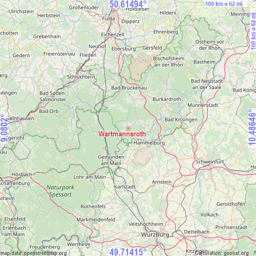
Wartmannsroth GPS coordinates[2]
50° 10' 0.012" North, 9° 46' 59.988" East
| Map corner | latitude | longitude |
|---|---|---|
| Upper-left | 50.61494°, | 9.0802° |
| Center: | 50.16667°, | 9.78333° |
| Lower-right: | 49.71415°, | 10.48646° |
| Map W x H: | 100.2×100.2 km | = 62.3×62.3mi |
| max Lat: | 55.01917° ⇑59.7% North |
| Wartmannsroth: | 50.16667° |
| min Lat: | ⇓40.3% South 47.40724° |
| min Long | Wartmannsroth | max Long |
| 5.92978° | 9.78333° | 14.98853° |
| W 46.9%⇐ | ⇒53.1% E |
Elevation
Elevation of Wartmannsroth is 331 m = 1086 ft, and this is 81.9 m = 269 ft above average elevation for this country.
| Max E: |
1256 m = 4121 ft | 33.6% |
| Wartmannsroth | 331 m 1086 ft | |
| Avg. | 249.1 m = 817 ft | |
Min E: |
-5 m = -16 ft | 66.4% |
See also: Germany elevation on elevation.city.
Geographical zone
Wartmannsroth is located in North temperate zone (between Tropic of Cancer and the Arctic Circle). Distance of this North polar circle is 1823.2 km =1132.9 mi to North.| Distance of | km | miles | from Wartmannsroth |
|---|---|---|---|
| North Pole | 4429.1 | 2752.1 | to North |
| Arctic Circle | 1823.2 | 1132.9 | to North |
| Tropic Cancer | 2972.1 | 1846.8 | to South |
| Equator | 5578 | 3466 | to South |


Nearby cities:
15 places around Wartmannsroth: (largest is in red/bold)
• Burgsinn
9.6 km =6 mi,  258°
258°
• Elfershausen
12.9 km =8 mi,  99°
99°
• Fuchsstadt
12.5 km =7.8 mi,  121°
121°
• Gemünden am Main
14.2 km =8.8 mi,  202°
202°
• Gräfendorf
5.8 km =3.6 mi,  211°
211°
• Hammelburg
9.5 km =5.9 mi,  126°
126°
• Karsbach
14 km =8.7 mi,  179°
179°
• Mittelsinn
12.2 km =7.6 mi,  283°
283°
• Oberleichtersbach
13 km =8.1 mi,  5°
5°
• Obersinn
12.8 km =8 mi,  291°
291°
• Oberthulba
13 km =8.1 mi,  73°
73°
• Rieneck
12.6 km =7.8 mi,  229°
229°
• Schondra
12.6 km =7.8 mi,  26°
26°
• Schönau
11 km =6.8 mi, 203°
• Zeitlofs
13.2 km =8.2 mi,  323°
323°
Sources, notices
• [Note1] Compared only with cities in Germany existing in our database
• [Src1] Map data: © OpenStreetMap contributors (CC-BY-SA)
• [Src2] Other city data from geonames.org with taken over terms of usage.
• [Src3] Geographical zone / Annual Mean Temperature by Robert A. Rohde @ Wikipedia
