Fuchsstadt geodata
Fuchsstadt (Bavaria) is a seat of a fourth-order administrative division; located in Germany in Europe/Berlin (GMT+2) time zone. With population of 1,819 people, there are 5318 cities with bigger population in this country. Compared to other cities in Germany, 61.1% of cities are located further ↑North; 51% of cities are located further →East and 52.3% of cities have higher elevation than Fuchsstadt. Note1
Administrative division(s):
- Level 1: Bavaria
- Level 2: Regierungsbezirk Unterfranken
- Level 3: Landkreis Bad Kissingen
- Level 4: Fuchsstadt


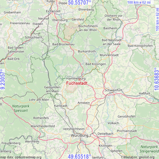
Fuchsstadt GPS coordinates[2]
50° 6' 29.7" North, 9° 56' 1.32" East
| Map corner | latitude | longitude |
|---|---|---|
| Upper-left | 50.55707°, | 9.23057° |
| Center: | 50.10825°, | 9.9337° |
| Lower-right: | 49.65518°, | 10.63683° |
| Map W x H: | 100.3×100.3 km | = 62.3×62.3mi |
| max Lat: | 55.01917° ⇑61.1% North |
| Fuchsstadt: | 50.10825° |
| min Lat: | ⇓38.9% South 47.40724° |
| min Long | Fuchsstadt | max Long |
| 5.92978° | 9.9337° | 14.98853° |
| W 49%⇐ | ⇒51% E |
Elevation
Elevation of Fuchsstadt is 209 m = 686 ft, and this is 40.1 m = 132 ft below average elevation for this country.
| Max E: |
1256 m = 4121 ft | 52.3% |
| Avg. | 249.1 m = 817 ft | |
| Fuchsstadt | 209 m = 686 ft | |
Min E: |
-5 m = -16 ft | 47.7% |
See also: Germany elevation on elevation.city.
Geographical zone
Fuchsstadt is located in North temperate zone (between Tropic of Cancer and the Arctic Circle). Distance of this North polar circle is 1829.7 km =1136.9 mi to North.| Distance of | km | miles | from Fuchsstadt |
|---|---|---|---|
| North Pole | 4435.5 | 2756.1 | to North |
| Arctic Circle | 1829.7 | 1136.9 | to North |
| Tropic Cancer | 2965.6 | 1842.7 | to South |
| Equator | 5571.5 | 3462 | to South |


Nearby cities:
15 places around Fuchsstadt: (largest is in red/bold)
• Arnstein
14.7 km =9.1 mi,  169°
169°
• Aura an der Saale
8.1 km =5 mi,  40°
40°
• Bad Kissingen
14.7 km =9.1 mi, 44°
• Elfershausen
4.8 km =3 mi,  24°
24°
• Euerdorf
7.8 km =4.8 mi,  54°
54°
• Gräfendorf
13.9 km =8.6 mi,  276°
276°
• Gössenheim
14.8 km =9.2 mi,  226°
226°
• Hammelburg
3.1 km =1.9 mi,  286°
286°
• Karsbach
13 km =8.1 mi, 234°
• Oberthulba
10.3 km =6.4 mi,  10°
10°
• Poppenhausen
14.9 km =9.3 mi,  93°
93°
• Ramsthal
10.2 km =6.3 mi,  69°
69°
• Sulzthal
7.7 km =4.8 mi, 69°
• Wartmannsroth
12.5 km =7.8 mi,  301°
301°
• Wasserlosen
7 km =4.3 mi,  102°
102°
Sources, notices
• [Note1] Compared only with cities in Germany existing in our database
• [Src1] Map data: © OpenStreetMap contributors (CC-BY-SA)
• [Src2] Other city data from geonames.org with taken over terms of usage.
• [Src3] Geographical zone / Annual Mean Temperature by Robert A. Rohde @ Wikipedia
