Oberthulba geodata
Oberthulba (Bavaria) is a populated place; located in Germany in Europe/Berlin (GMT+2) time zone. With population of 5,151 people, there are 2769 cities with bigger population in this country. Compared to other cities in Germany, 59% of cities are located further ↑North; 50.7% of cities are located further →East and 56.9% of cities have lower elevation than Oberthulba. Note1
Administrative division(s):
- Level 1: Bavaria
- Level 2: Regierungsbezirk Unterfranken
- Level 3: Landkreis Bad Kissingen
- Level 4: Oberthulba, Markt


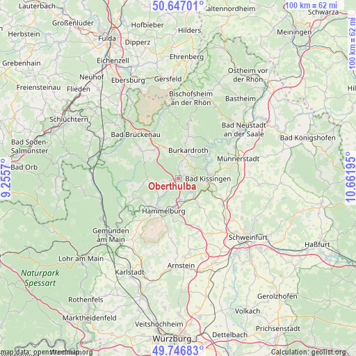
Oberthulba GPS coordinates[2]
50° 11' 56.544" North, 9° 57' 31.752" East
| Map corner | latitude | longitude |
|---|---|---|
| Upper-left | 50.64701°, | 9.2557° |
| Center: | 50.19904°, | 9.95882° |
| Lower-right: | 49.74683°, | 10.66195° |
| Map W x H: | 100.1×100.1 km | = 62.2×62.2mi |
| max Lat: | 55.01917° ⇑59% North |
| Oberthulba: | 50.19904° |
| min Lat: | ⇓41% South 47.40724° |
| min Long | Oberthulba | max Long |
| 5.92978° | 9.95882° | 14.98853° |
| W 49.3%⇐ | ⇒50.7% E |
Elevation
Elevation of Oberthulba is 271 m = 889 ft, and this is 21.9 m = 72 ft above average elevation for this country.
| Max E: |
1256 m = 4121 ft | 43.1% |
| Oberthulba | 271 m 889 ft | |
| Avg. | 249.1 m = 817 ft | |
Min E: |
-5 m = -16 ft | 56.9% |
See also: Germany elevation on elevation.city.
Geographical zone
Oberthulba is located in North temperate zone (between Tropic of Cancer and the Arctic Circle). Distance of this North polar circle is 1819.6 km =1130.6 mi to North.| Distance of | km | miles | from Oberthulba |
|---|---|---|---|
| North Pole | 4425.5 | 2749.9 | to North |
| Arctic Circle | 1819.6 | 1130.6 | to North |
| Tropic Cancer | 2975.7 | 1849 | to South |
| Equator | 5581.6 | 3468.2 | to South |


Nearby cities:
15 places around Oberthulba: (largest is in red/bold)
• Aura an der Saale
5.2 km =3.2 mi,  138°
138°
• Bad Bocklet
11.4 km =7.1 mi,  48°
48°
• Bad Kissingen
8.5 km =5.3 mi,  87°
87°
• Burkardroth
8.4 km =5.2 mi,  16°
16°
• Elfershausen
5.7 km =3.5 mi,  178°
178°
• Euerdorf
7.3 km =4.5 mi, 140°
• Fuchsstadt
10.3 km =6.4 mi,  190°
190°
• Geroda
10.1 km =6.3 mi,  333°
333°
• Hammelburg
10.4 km =6.5 mi,  207°
207°
• Nüdlingen
11.9 km =7.4 mi,  78°
78°
• Ramsthal
10.1 km =6.3 mi,  130°
130°
• Schondra
10.3 km =6.4 mi,  318°
318°
• Sulzthal
9.2 km =5.7 mi, 143°
• Wartmannsroth
13 km =8.1 mi,  253°
253°
• Wasserlosen
12.7 km =7.9 mi,  156°
156°
Sources, notices
• [Note1] Compared only with cities in Germany existing in our database
• [Src1] Map data: © OpenStreetMap contributors (CC-BY-SA)
• [Src2] Other city data from geonames.org with taken over terms of usage.
• [Src3] Geographical zone / Annual Mean Temperature by Robert A. Rohde @ Wikipedia
