Obersinn geodata
Obersinn (Bavaria) is a populated place; located in Germany in Europe/Berlin (GMT+2) time zone. With population of 1,048 people, there are 7013 cities with bigger population in this country. Compared to other cities in Germany, 58.8% of cities are located further ↑North; 55.9% of cities are located further →East and 52.4% of cities have higher elevation than Obersinn. Note1
Administrative division(s):
- Level 1: Bavaria
- Level 2: Regierungsbezirk Unterfranken
- Level 3: Landkreis Main-Spessart
- Level 4: Obersinn, Markt


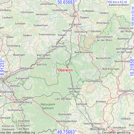
Obersinn GPS coordinates[2]
50° 12' 31.5" North, 9° 36' 55.62" East
| Map corner | latitude | longitude |
|---|---|---|
| Upper-left | 50.65663°, | 8.91233° |
| Center: | 50.20875°, | 9.61545° |
| Lower-right: | 49.75663°, | 10.31858° |
| Map W x H: | 100.1×100.1 km | = 62.2×62.2mi |
| max Lat: | 55.01917° ⇑58.8% North |
| Obersinn: | 50.20875° |
| min Lat: | ⇓41.2% South 47.40724° |
| min Long | Obersinn | max Long |
| 5.92978° | 9.61545° | 14.98853° |
| W 44.1%⇐ | ⇒55.9% E |
Elevation
Elevation of Obersinn is 208 m = 682 ft, and this is 41.1 m = 135 ft below average elevation for this country.
| Max E: |
1256 m = 4121 ft | 52.4% |
| Avg. | 249.1 m = 817 ft | |
| Obersinn | 208 m = 682 ft | |
Min E: |
-5 m = -16 ft | 47.6% |
See also: Germany elevation on elevation.city.
Geographical zone
Obersinn is located in North temperate zone (between Tropic of Cancer and the Arctic Circle). Distance of this North polar circle is 1818.5 km =1130 mi to North.| Distance of | km | miles | from Obersinn |
|---|---|---|---|
| North Pole | 4424.4 | 2749.2 | to North |
| Arctic Circle | 1818.5 | 1130 | to North |
| Tropic Cancer | 2976.8 | 1849.7 | to South |
| Equator | 5582.7 | 3468.9 | to South |


Nearby cities:
15 places around Obersinn: (largest is in red/bold)
• Aura im Sinngrund
4.4 km =2.7 mi,  219°
219°
• Bad Brückenau
16.6 km =10.3 mi,  48°
48°
• Burgsinn
7 km =4.3 mi,  158°
158°
• Fellen
6.9 km =4.3 mi,  199°
199°
• Gemünden am Main
18.8 km =11.7 mi, 159°
• Gräfendorf
13.1 km =8.1 mi,  137°
137°
• Mittelsinn
1.8 km =1.1 mi,  176°
176°
• Oberleichtersbach
15.5 km =9.6 mi,  57°
57°
• Rieneck
13 km =8.1 mi,  169°
169°
• Schlüchtern
16.8 km =10.4 mi,  337°
337°
• Schondra
18.8 km =11.7 mi,  69°
69°
• Schönau
16.6 km =10.3 mi,  152°
152°
• Steinau an der Straße
15.9 km =9.9 mi,  317°
317°
• Wartmannsroth
12.8 km =8 mi,  111°
111°
• Zeitlofs
7.2 km =4.5 mi,  34°
34°
Sources, notices
• [Note1] Compared only with cities in Germany existing in our database
• [Src1] Map data: © OpenStreetMap contributors (CC-BY-SA)
• [Src2] Other city data from geonames.org with taken over terms of usage.
• [Src3] Geographical zone / Annual Mean Temperature by Robert A. Rohde @ Wikipedia
