Wangen geodata
Wangen (Saxony-Anhalt) is a section of populated place; located in Germany in Europe/Berlin (GMT+2) time zone. With population of 546 people, there are 9105 cities with bigger population in this country. Compared to other cities in Germany, 62.8% of cities are located further ↓South; 74.9% of cities are located further ←West and 65.2% of cities have higher elevation than Wangen. Note1
Administrative division(s):
- Level 1: Saxony-Anhalt
- Level 3: Burgenlandkreis
- Level 4: Nebra (Unstrut)


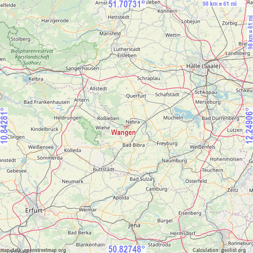
Wangen GPS coordinates[2]
51° 16' 10.2" North, 11° 32' 45.348" East
| Map corner | latitude | longitude |
|---|---|---|
| Upper-left | 51.70731°, | 10.84281° |
| Center: | 51.2695°, | 11.54593° |
| Lower-right: | 50.82748°, | 12.24906° |
| Map W x H: | 97.8×97.8 km | = 60.8×60.8mi |
| max Lat: | 55.01917° ⇑37.2% North |
| Wangen: | 51.2695° |
| min Lat: | ⇓62.8% South 47.40724° |
| min Long | Wangen | max Long |
| 5.92978° | 11.54593° | 14.98853° |
| W 74.9%⇐ | ⇒25.1% E |
Elevation
Elevation of Wangen is 119 m = 390 ft, and this is 130.1 m = 427 ft below average elevation for this country.
| Max E: |
1256 m = 4121 ft | 65.2% |
| Avg. | 249.1 m = 817 ft | |
| Wangen | 119 m = 390 ft | |
Min E: |
-5 m = -16 ft | 34.8% |
See also: Germany elevation on elevation.city.
Geographical zone
Wangen is located in North temperate zone (between Tropic of Cancer and the Arctic Circle). Distance of this North polar circle is 1700.5 km =1056.6 mi to North.| Distance of | km | miles | from Wangen |
|---|---|---|---|
| North Pole | 4306.4 | 2675.9 | to North |
| Arctic Circle | 1700.5 | 1056.6 | to North |
| Tropic Cancer | 3094.7 | 1923 | to South |
| Equator | 5700.6 | 3542.2 | to South |


Nearby cities:
15 places around Wangen: (largest is in red/bold)
• Altenroda
3.5 km =2.2 mi,  158°
158°
• Bad Bibra
7.4 km =4.6 mi, 158°
• Burgscheidungen
7.1 km =4.4 mi,  110°
110°
• Karsdorf
7.8 km =4.8 mi,  88°
88°
• Memleben
3.8 km =2.4 mi,  263°
263°
• Nebra
3 km =1.9 mi,  46°
46°
• Roßleben
8.4 km =5.2 mi,  292°
292°
• Saubach
6.3 km =3.9 mi,  193°
193°
• Schmon
8.4 km =5.2 mi,  359°
359°
• Steigra
9.1 km =5.7 mi,  68°
68°
• Vitzenburg
3.9 km =2.4 mi,  23°
23°
• Weißenschirmbach
5 km =3.1 mi,  3°
3°
• Wiehe
9.3 km =5.8 mi,  267°
267°
• Wohlmirstedt
6.4 km =4 mi,  247°
247°
• Ziegelroda
9 km =5.6 mi,  321°
321°
Sources, notices
• [Note1] Compared only with cities in Germany existing in our database
• [Src1] Map data: © OpenStreetMap contributors (CC-BY-SA)
• [Src2] Other city data from geonames.org with taken over terms of usage.
• [Src3] Geographical zone / Annual Mean Temperature by Robert A. Rohde @ Wikipedia
