Karsdorf geodata
Karsdorf (Saxony-Anhalt) is a seat of a fourth-order administrative division; located in Germany in Europe/Berlin (GMT+2) time zone. With population of 2,063 people, there are 4979 cities with bigger population in this country. Compared to other cities in Germany, 62.8% of cities are located further ↓South; 76.6% of cities are located further ←West and 64.7% of cities have higher elevation than Karsdorf. Note1


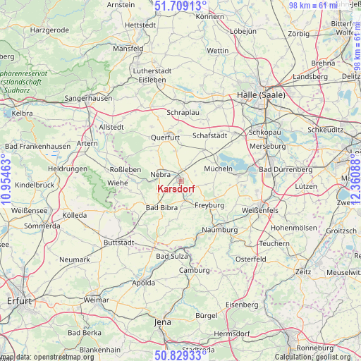
Karsdorf GPS coordinates[2]
51° 16' 16.824" North, 11° 39' 27.9" East
| Map corner | latitude | longitude |
|---|---|---|
| Upper-left | 51.70913°, | 10.95463° |
| Center: | 51.27134°, | 11.65775° |
| Lower-right: | 50.82933°, | 12.36088° |
| Map W x H: | 97.8×97.8 km | = 60.8×60.8mi |
| max Lat: | 55.01917° ⇑37.2% North |
| Karsdorf: | 51.27134° |
| min Lat: | ⇓62.8% South 47.40724° |
| min Long | Karsdorf | max Long |
| 5.92978° | 11.65775° | 14.98853° |
| W 76.6%⇐ | ⇒23.4% E |
Elevation
Elevation of Karsdorf is 122 m = 400 ft, and this is 127.1 m = 417 ft below average elevation for this country.
| Max E: |
1256 m = 4121 ft | 64.7% |
| Avg. | 249.1 m = 817 ft | |
| Karsdorf | 122 m = 400 ft | |
Min E: |
-5 m = -16 ft | 35.3% |
See also: Germany elevation on elevation.city.
Geographical zone
Karsdorf is located in North temperate zone (between Tropic of Cancer and the Arctic Circle). Distance of this North polar circle is 1700.3 km =1056.5 mi to North.| Distance of | km | miles | from Karsdorf |
|---|---|---|---|
| North Pole | 4306.2 | 2675.7 | to North |
| Arctic Circle | 1700.3 | 1056.5 | to North |
| Tropic Cancer | 3094.9 | 1923.1 | to South |
| Equator | 5700.8 | 3542.3 | to South |


Nearby cities:
15 places around Karsdorf: (largest is in red/bold)
• Altenroda
7.3 km =4.5 mi,  241°
241°
• Bad Bibra
8.7 km =5.4 mi,  215°
215°
• Balgstädt
9 km =5.6 mi,  144°
144°
• Barnstädt
8.2 km =5.1 mi,  350°
350°
• Burgscheidungen
2.9 km =1.8 mi,  202°
202°
• Freyburg
10 km =6.2 mi,  129°
129°
• Gleina
4.6 km =2.9 mi,  108°
108°
• Laucha
5.5 km =3.4 mi,  163°
163°
• Nebra
5.9 km =3.7 mi,  288°
288°
• Nemsdorf-Göhrendorf
8.8 km =5.5 mi,  356°
356°
• Steigra
3.2 km =2 mi,  11°
11°
• Vitzenburg
7.1 km =4.4 mi,  298°
298°
• Wangen
7.8 km =4.8 mi,  268°
268°
• Weißenschirmbach
8.8 km =5.5 mi, 302°
• Öchlitz
9.3 km =5.8 mi,  51°
51°
Sources, notices
• [Note1] Compared only with cities in Germany existing in our database
• [Src1] Map data: © OpenStreetMap contributors (CC-BY-SA)
• [Src2] Other city data from geonames.org with taken over terms of usage.
• [Src3] Geographical zone / Annual Mean Temperature by Robert A. Rohde @ Wikipedia
