Schmon geodata
Schmon (Saxony-Anhalt) is a populated place; located in Germany in Europe/Berlin (GMT+2) time zone. With population of 864 people, there are 7647 cities with bigger population in this country. Compared to other cities in Germany, 63.9% of cities are located further ↓South; 74.9% of cities are located further ←West and 55% of cities have higher elevation than Schmon. Note1


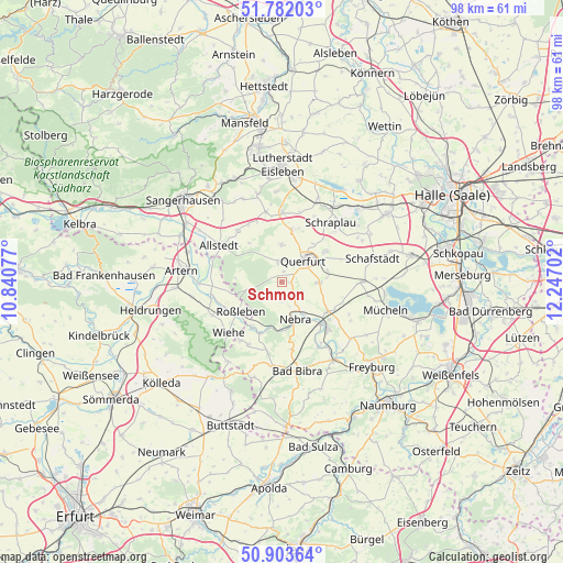
Schmon GPS coordinates[2]
51° 20' 41.784" North, 11° 32' 38.004" East
| Map corner | latitude | longitude |
|---|---|---|
| Upper-left | 51.78203°, | 10.84077° |
| Center: | 51.34494°, | 11.54389° |
| Lower-right: | 50.90364°, | 12.24702° |
| Map W x H: | 97.7×97.7 km | = 60.7×60.7mi |
| max Lat: | 55.01917° ⇑36.1% North |
| Schmon: | 51.34494° |
| min Lat: | ⇓63.9% South 47.40724° |
| min Long | Schmon | max Long |
| 5.92978° | 11.54389° | 14.98853° |
| W 74.9%⇐ | ⇒25.1% E |
Elevation
Elevation of Schmon is 189 m = 620 ft, and this is 60.1 m = 197 ft below average elevation for this country.
| Max E: |
1256 m = 4121 ft | 55% |
| Avg. | 249.1 m = 817 ft | |
| Schmon | 189 m = 620 ft | |
Min E: |
-5 m = -16 ft | 45% |
See also: Germany elevation on elevation.city.
Geographical zone
Schmon is located in North temperate zone (between Tropic of Cancer and the Arctic Circle). Distance of this North polar circle is 1692.2 km =1051.5 mi to North.| Distance of | km | miles | from Schmon |
|---|---|---|---|
| North Pole | 4298 | 2670.7 | to North |
| Arctic Circle | 1692.2 | 1051.5 | to North |
| Tropic Cancer | 3103.1 | 1928.2 | to South |
| Equator | 5709 | 3547.4 | to South |


Nearby cities:
15 places around Schmon: (largest is in red/bold)
• Barnstädt
6.5 km =4 mi,  90°
90°
• Farnstädt
10 km =6.2 mi,  9°
9°
• Karsdorf
11.4 km =7.1 mi,  135°
135°
• Memleben
9.5 km =5.9 mi,  202°
202°
• Mittelhausen
11.4 km =7.1 mi,  330°
330°
• Nebra
6.7 km =4.2 mi,  159°
159°
• Nemsdorf-Göhrendorf
7.4 km =4.6 mi, 85°
• Obhausen
9.2 km =5.7 mi,  55°
55°
• Querfurt
5.6 km =3.5 mi,  44°
44°
• Roßleben
9.2 km =5.7 mi,  236°
236°
• Steigra
9.9 km =6.2 mi,  120°
120°
• Vitzenburg
5.1 km =3.2 mi, 160°
• Wangen
8.4 km =5.2 mi,  179°
179°
• Weißenschirmbach
3.5 km =2.2 mi,  172°
172°
• Ziegelroda
5.6 km =3.5 mi,  256°
256°
Sources, notices
• [Note1] Compared only with cities in Germany existing in our database
• [Src1] Map data: © OpenStreetMap contributors (CC-BY-SA)
• [Src2] Other city data from geonames.org with taken over terms of usage.
• [Src3] Geographical zone / Annual Mean Temperature by Robert A. Rohde @ Wikipedia
