Roßleben geodata
Roßleben (Thuringia) is a populated place; located in Germany in Europe/Berlin (GMT+2) time zone. With population of 6,216 people, there are 2395 cities with bigger population in this country. Compared to other cities in Germany, 63.2% of cities are located further ↓South; 73.3% of cities are located further ←West and 63.2% of cities have higher elevation than Roßleben. Note1
Administrative division(s):
- Level 1: Thuringia
- Level 3: Kyffhäuserkreis
- Level 4: Stadt Roßleben-Wiehe


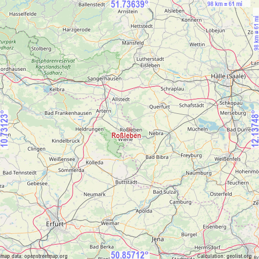
Roßleben GPS coordinates[2]
51° 17' 55.896" North, 11° 26' 3.66" East
| Map corner | latitude | longitude |
|---|---|---|
| Upper-left | 51.73639°, | 10.73123° |
| Center: | 51.29886°, | 11.43435° |
| Lower-right: | 50.85712°, | 12.13748° |
| Map W x H: | 97.8×97.8 km | = 60.8×60.8mi |
| max Lat: | 55.01917° ⇑36.8% North |
| Roßleben: | 51.29886° |
| min Lat: | ⇓63.2% South 47.40724° |
| min Long | Roßleben | max Long |
| 5.92978° | 11.43435° | 14.98853° |
| W 73.3%⇐ | ⇒26.7% E |
Elevation
Elevation of Roßleben is 131 m = 430 ft, and this is 118.1 m = 387 ft below average elevation for this country.
| Max E: |
1256 m = 4121 ft | 63.2% |
| Avg. | 249.1 m = 817 ft | |
| Roßleben | 131 m = 430 ft | |
Min E: |
-5 m = -16 ft | 36.8% |
See also: Germany elevation on elevation.city.
Geographical zone
Roßleben is located in North temperate zone (between Tropic of Cancer and the Arctic Circle). Distance of this North polar circle is 1697.3 km =1054.7 mi to North.| Distance of | km | miles | from Roßleben |
|---|---|---|---|
| North Pole | 4303.2 | 2673.9 | to North |
| Arctic Circle | 1697.3 | 1054.7 | to North |
| Tropic Cancer | 3098 | 1925 | to South |
| Equator | 5703.9 | 3544.2 | to South |


Nearby cities:
15 places around Roßleben: (largest is in red/bold)
• Donndorf
4.3 km =2.7 mi,  262°
262°
• Gehofen
8.4 km =5.2 mi,  288°
288°
• Heygendorf
7.7 km =4.8 mi,  319°
319°
• Kalbsrieth
8.1 km =5 mi,  306°
306°
• Lossa
8.7 km =5.4 mi,  191°
191°
• Memleben
5.4 km =3.4 mi,  132°
132°
• Nausitz
7.3 km =4.5 mi, 285°
• Schmon
9.2 km =5.7 mi,  56°
56°
• Schönewerda
5.5 km =3.4 mi,  300°
300°
• Vitzenburg
9.3 km =5.8 mi,  88°
88°
• Wangen
8.4 km =5.2 mi,  112°
112°
• Weißenschirmbach
8.3 km =5.2 mi,  78°
78°
• Wiehe
4 km =2.5 mi,  202°
202°
• Wohlmirstedt
6 km =3.7 mi,  161°
161°
• Ziegelroda
4.4 km =2.7 mi,  30°
30°
Sources, notices
• [Note1] Compared only with cities in Germany existing in our database
• [Src1] Map data: © OpenStreetMap contributors (CC-BY-SA)
• [Src2] Other city data from geonames.org with taken over terms of usage.
• [Src3] Geographical zone / Annual Mean Temperature by Robert A. Rohde @ Wikipedia
