Glauchau geodata
Glauchau (Saxony) is a populated place; located in Germany in Europe/Berlin (GMT+2) time zone. With population of 26,473 people, there are 545 cities with bigger population in this country. Compared to other cities in Germany, 54.6% of cities are located further ↓South; 88.3% of cities are located further ←West and 56% of cities have lower elevation than Glauchau. Note1


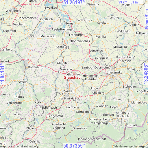
Glauchau GPS coordinates[2]
50° 49' 11.532" North, 12° 32' 41.748" East
| Map corner | latitude | longitude |
|---|---|---|
| Upper-left | 51.26197°, | 11.84181° |
| Center: | 50.81987°, | 12.54493° |
| Lower-right: | 50.37355°, | 13.24806° |
| Map W x H: | 98.8×98.8 km | = 61.4×61.4mi |
| max Lat: | 55.01917° ⇑45.4% North |
| Glauchau: | 50.81987° |
| min Lat: | ⇓54.6% South 47.40724° |
| min Long | Glauchau | max Long |
| 5.92978° | 12.54493° | 14.98853° |
| W 88.3%⇐ | ⇒11.7% E |
Elevation
Elevation of Glauchau is 266 m = 873 ft, and this is 16.9 m = 55 ft above average elevation for this country.
| Max E: |
1256 m = 4121 ft | 44% |
| Glauchau | 266 m 873 ft | |
| Avg. | 249.1 m = 817 ft | |
Min E: |
-5 m = -16 ft | 56% |
See also: Germany elevation on elevation.city.
Geographical zone
Glauchau is located in North temperate zone (between Tropic of Cancer and the Arctic Circle). Distance of this North polar circle is 1750.5 km =1087.7 mi to North.| Distance of | km | miles | from Glauchau |
|---|---|---|---|
| North Pole | 4356.4 | 2706.9 | to North |
| Arctic Circle | 1750.5 | 1087.7 | to North |
| Tropic Cancer | 3044.7 | 1891.9 | to South |
| Equator | 5650.6 | 3511.1 | to South |


Nearby cities:
15 places around Glauchau: (largest is in red/bold)
• Bernsdorf
10.4 km =6.5 mi,  124°
124°
• Callenberg
7.1 km =4.4 mi,  61°
61°
• Dennheritz
5.6 km =3.5 mi,  263°
263°
• Hartmannsdorf
10.8 km =6.7 mi,  230°
230°
• Lichtenstein
9.2 km =5.7 mi,  139°
139°
• Meerane
6.4 km =4 mi,  298°
298°
• Mülsen
7.9 km =4.9 mi,  168°
168°
• Oberwiera
7.7 km =4.8 mi,  359°
359°
• Pfaffroda
5.1 km =3.2 mi,  335°
335°
• Ponitz
9.5 km =5.9 mi, 296°
• Remse
3.7 km =2.3 mi,  24°
24°
• Sankt Egidien
6.7 km =4.2 mi, 124°
• Schönberg
6.5 km =4 mi,  324°
324°
• Waldenburg
7.4 km =4.6 mi,  31°
31°
• Weißenborn
10.4 km =6.5 mi,  210°
210°
Sources, notices
• [Note1] Compared only with cities in Germany existing in our database
• [Src1] Map data: © OpenStreetMap contributors (CC-BY-SA)
• [Src2] Other city data from geonames.org with taken over terms of usage.
• [Src3] Geographical zone / Annual Mean Temperature by Robert A. Rohde @ Wikipedia
