Waigolshausen geodata
Waigolshausen (Bavaria) is a seat of a fourth-order administrative division; located in Germany in Europe/Berlin (GMT+2) time zone. With population of 2,931 people, there are 4064 cities with bigger population in this country. Compared to other cities in Germany, 64.8% of cities are located further ↑North; 52% of cities are located further ←West and 52.2% of cities have lower elevation than Waigolshausen. Note1
Administrative division(s):
- Level 1: Bavaria
- Level 2: Regierungsbezirk Unterfranken
- Level 3: Landkreis Schweinfurt
- Level 4: Waigolshausen


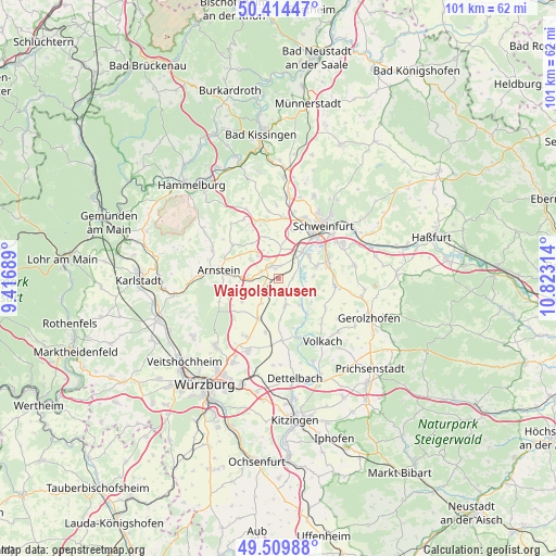
Waigolshausen GPS coordinates[2]
49° 57' 51.48" North, 10° 7' 12.036" East
| Map corner | latitude | longitude |
|---|---|---|
| Upper-left | 50.41447°, | 9.41689° |
| Center: | 49.9643°, | 10.12001° |
| Lower-right: | 49.50988°, | 10.82314° |
| Map W x H: | 100.6×100.6 km | = 62.5×62.5mi |
| max Lat: | 55.01917° ⇑64.8% North |
| Waigolshausen: | 49.9643° |
| min Lat: | ⇓35.2% South 47.40724° |
| min Long | Waigolshausen | max Long |
| 5.92978° | 10.12001° | 14.98853° |
| W 52%⇐ | ⇒48% E |
Elevation
Elevation of Waigolshausen is 241 m = 791 ft, and this is 8.1 m = 27 ft below average elevation for this country.
| Max E: |
1256 m = 4121 ft | 47.8% |
| Avg. | 249.1 m = 817 ft | |
| Waigolshausen | 241 m = 791 ft | |
Min E: |
-5 m = -16 ft | 52.2% |
See also: Germany elevation on elevation.city.
Geographical zone
Waigolshausen is located in North temperate zone (between Tropic of Cancer and the Arctic Circle). Distance of this North polar circle is 1845.7 km =1146.9 mi to North.| Distance of | km | miles | from Waigolshausen |
|---|---|---|---|
| North Pole | 4451.6 | 2766.1 | to North |
| Arctic Circle | 1845.7 | 1146.9 | to North |
| Tropic Cancer | 2949.6 | 1832.8 | to South |
| Equator | 5555.5 | 3452 | to South |


Nearby cities:
15 places around Waigolshausen: (largest is in red/bold)
• Arnstein
10.8 km =6.7 mi,  277°
277°
• Bergrheinfeld
6.7 km =4.2 mi,  40°
40°
• Bergtheim
8.1 km =5 mi,  208°
208°
• Euerbach
10.9 km =6.8 mi,  6°
6°
• Geldersheim
9.1 km =5.7 mi,  16°
16°
• Grafenrheinfeld
7 km =4.3 mi,  55°
55°
• Kolitzheim
9.7 km =6 mi,  123°
123°
• Niederwerrn
11.7 km =7.3 mi, 22°
• Oberpleichfeld
10 km =6.2 mi,  193°
193°
• Prosselsheim
11.3 km =7 mi,  177°
177°
• Röthlein
7.2 km =4.5 mi,  72°
72°
• Schwanfeld
4.9 km =3 mi,  164°
164°
• Schwebheim
9.6 km =6 mi, 72°
• Werneck
2.5 km =1.6 mi,  322°
322°
• Wipfeld
6.3 km =3.9 mi,  147°
147°
Sources, notices
• [Note1] Compared only with cities in Germany existing in our database
• [Src1] Map data: © OpenStreetMap contributors (CC-BY-SA)
• [Src2] Other city data from geonames.org with taken over terms of usage.
• [Src3] Geographical zone / Annual Mean Temperature by Robert A. Rohde @ Wikipedia
