Prosselsheim geodata
Prosselsheim (Bavaria) is a seat of a fourth-order administrative division; located in Germany in Europe/Berlin (GMT+2) time zone. With population of 1,213 people, there are 6527 cities with bigger population in this country. Compared to other cities in Germany, 67.5% of cities are located further ↑North; 52% of cities are located further ←West and 56.5% of cities have lower elevation than Prosselsheim. Note1
Administrative division(s):
- Level 1: Bavaria
- Level 2: Regierungsbezirk Unterfranken
- Level 3: Landkreis Würzburg
- Level 4: Prosselsheim


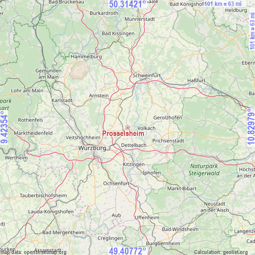
Prosselsheim GPS coordinates[2]
49° 51' 47.124" North, 10° 7' 35.976" East
| Map corner | latitude | longitude |
|---|---|---|
| Upper-left | 50.31421°, | 9.42354° |
| Center: | 49.86309°, | 10.12666° |
| Lower-right: | 49.40772°, | 10.82979° |
| Map W x H: | 100.8×100.8 km | = 62.6×62.6mi |
| max Lat: | 55.01917° ⇑67.5% North |
| Prosselsheim: | 49.86309° |
| min Lat: | ⇓32.5% South 47.40724° |
| min Long | Prosselsheim | max Long |
| 5.92978° | 10.12666° | 14.98853° |
| W 52%⇐ | ⇒48% E |
Elevation
Elevation of Prosselsheim is 269 m = 883 ft, and this is 19.9 m = 65 ft above average elevation for this country.
| Max E: |
1256 m = 4121 ft | 43.5% |
| Prosselsheim | 269 m 883 ft | |
| Avg. | 249.1 m = 817 ft | |
Min E: |
-5 m = -16 ft | 56.5% |
See also: Germany elevation on elevation.city.
Geographical zone
Prosselsheim is located in North temperate zone (between Tropic of Cancer and the Arctic Circle). Distance of this North polar circle is 1856.9 km =1153.8 mi to North.| Distance of | km | miles | from Prosselsheim |
|---|---|---|---|
| North Pole | 4462.8 | 2773.1 | to North |
| Arctic Circle | 1856.9 | 1153.8 | to North |
| Tropic Cancer | 2938.3 | 1825.8 | to South |
| Equator | 5544.3 | 3445.1 | to South |


Nearby cities:
15 places around Prosselsheim: (largest is in red/bold)
• Albertshofen
11.1 km =6.9 mi,  165°
165°
• Bergtheim
5.9 km =3.7 mi,  313°
313°
• Dettelbach
7.2 km =4.5 mi,  157°
157°
• Estenfeld
9.5 km =5.9 mi,  246°
246°
• Kolitzheim
9.7 km =6 mi,  52°
52°
• Kürnach
6.8 km =4.2 mi,  257°
257°
• Mainstockheim
10.3 km =6.4 mi, 171°
• Nordheim
4.2 km =2.6 mi,  96°
96°
• Oberpleichfeld
3.2 km =2 mi,  298°
298°
• Rottendorf
10.7 km =6.6 mi,  222°
222°
• Schwanfeld
6.6 km =4.1 mi,  7°
7°
• Sommerach
6.9 km =4.3 mi,  122°
122°
• Unterpleichfeld
6 km =3.7 mi,  276°
276°
• Volkach
7.3 km =4.5 mi,  89°
89°
• Wipfeld
6.6 km =4.1 mi,  25°
25°
Sources, notices
• [Note1] Compared only with cities in Germany existing in our database
• [Src1] Map data: © OpenStreetMap contributors (CC-BY-SA)
• [Src2] Other city data from geonames.org with taken over terms of usage.
• [Src3] Geographical zone / Annual Mean Temperature by Robert A. Rohde @ Wikipedia
