Wachau geodata
Wachau (Saxony) is a seat of a fourth-order administrative division; located in Germany in Europe/Berlin (GMT+2) time zone. With population of 4,551 people, there are 3009 cities with bigger population in this country. Compared to other cities in Germany, 60.9% of cities are located further ↓South; 97.6% of cities are located further ←West and 50.4% of cities have higher elevation than Wachau. Note1


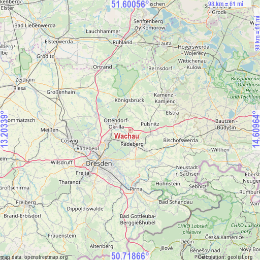
Wachau GPS coordinates[2]
51° 9' 42.192" North, 13° 54' 23.436" East
| Map corner | latitude | longitude |
|---|---|---|
| Upper-left | 51.60056°, | 13.20339° |
| Center: | 51.16172°, | 13.90651° |
| Lower-right: | 50.71866°, | 14.60964° |
| Map W x H: | 98.1×98.1 km | = 61×61mi |
| max Lat: | 55.01917° ⇑39.1% North |
| Wachau: | 51.16172° |
| min Lat: | ⇓60.9% South 47.40724° |
| min Long | Wachau | max Long |
| 5.92978° | 13.90651° | 14.98853° |
| W 97.6%⇐ | ⇒2.4% E |
Elevation
Elevation of Wachau is 222 m = 728 ft, and this is 27.1 m = 89 ft below average elevation for this country.
| Max E: |
1256 m = 4121 ft | 50.4% |
| Avg. | 249.1 m = 817 ft | |
| Wachau | 222 m = 728 ft | |
Min E: |
-5 m = -16 ft | 49.6% |
See also: Germany elevation on elevation.city.
Geographical zone
Wachau is located in North temperate zone (between Tropic of Cancer and the Arctic Circle). Distance of this North polar circle is 1712.5 km =1064.1 mi to North.| Distance of | km | miles | from Wachau |
|---|---|---|---|
| North Pole | 4318.4 | 2683.3 | to North |
| Arctic Circle | 1712.5 | 1064.1 | to North |
| Tropic Cancer | 3082.7 | 1915.5 | to South |
| Equator | 5688.7 | 3534.8 | to South |


Nearby cities:
15 places around Wachau: (largest is in red/bold)
• Arnsdorf
9.6 km =6 mi,  141°
141°
• Feldschlößchen
2.6 km =1.6 mi,  165°
165°
• Großnaundorf
4.6 km =2.9 mi,  23°
23°
• Großröhrsdorf
8.1 km =5 mi,  103°
103°
• Haselbachtal
11.7 km =7.3 mi,  45°
45°
• Hauswalde
12.6 km =7.8 mi,  94°
94°
• Höckendorf
7 km =4.3 mi,  1°
1°
• Königsbrück
11.4 km =7.1 mi,  359°
359°
• Laußnitz
9.9 km =6.2 mi,  350°
350°
• Lichtenberg
4.8 km =3 mi,  60°
60°
• Oberlichtenau
8.6 km =5.3 mi,  42°
42°
• Ohorn
9.8 km =6.1 mi,  83°
83°
• Ottendorf-Okrilla
5.6 km =3.5 mi,  295°
295°
• Radeberg
5.6 km =3.5 mi,  176°
176°
• Steina
10.9 km =6.8 mi,  66°
66°
Sources, notices
• [Note1] Compared only with cities in Germany existing in our database
• [Src1] Map data: © OpenStreetMap contributors (CC-BY-SA)
• [Src2] Other city data from geonames.org with taken over terms of usage.
• [Src3] Geographical zone / Annual Mean Temperature by Robert A. Rohde @ Wikipedia
