Feldschlößchen geodata
Feldschlößchen (Saxony) is a populated place; located in Germany in Europe/Berlin (GMT+2) time zone. With population of 900 people, there are 7521 cities with bigger population in this country. Compared to other cities in Germany, 60.6% of cities are located further ↓South; 97.6% of cities are located further ←West and 55% of cities have lower elevation than Feldschlößchen. Note1


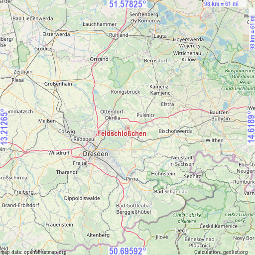
Feldschlößchen GPS coordinates[2]
51° 8' 21.084" North, 13° 54' 56.772" East
| Map corner | latitude | longitude |
|---|---|---|
| Upper-left | 51.57825°, | 13.21265° |
| Center: | 51.13919°, | 13.91577° |
| Lower-right: | 50.69592°, | 14.6189° |
| Map W x H: | 98.1×98.1 km | = 61×61mi |
| max Lat: | 55.01917° ⇑39.4% North |
| Feldschlößchen: | 51.13919° |
| min Lat: | ⇓60.6% South 47.40724° |
| min Long | Feldschlößche | max Long |
| 5.92978° | 13.91577° | 14.98853° |
| W 97.6%⇐ | ⇒2.4% E |
Elevation
Elevation of Feldschlößchen is 258 m = 846 ft, and this is 8.9 m = 29 ft above average elevation for this country.
| Max E: |
1256 m = 4121 ft | 45% |
| Feldschlößchen | 258 m 846 ft | |
| Avg. | 249.1 m = 817 ft | |
Min E: |
-5 m = -16 ft | 55% |
See also: Germany elevation on elevation.city.
Geographical zone
Feldschlößchen is located in North temperate zone (between Tropic of Cancer and the Arctic Circle). Distance of this North polar circle is 1715 km =1065.7 mi to North.| Distance of | km | miles | from Feldschlößchen |
|---|---|---|---|
| North Pole | 4320.9 | 2684.9 | to North |
| Arctic Circle | 1715 | 1065.7 | to North |
| Tropic Cancer | 3080.2 | 1913.9 | to South |
| Equator | 5686.1 | 3533.2 | to South |


Nearby cities:
15 places around Feldschlößchen: (largest is in red/bold)
• Albertstadt
12.1 km =7.5 mi,  239°
239°
• Arnsdorf
7.3 km =4.5 mi,  133°
133°
• Dürrröhrsdorf
13 km =8.1 mi,  154°
154°
• Großnaundorf
6.9 km =4.3 mi,  10°
10°
• Großröhrsdorf
7.2 km =4.5 mi,  84°
84°
• Hauswalde
12 km =7.5 mi, 83°
• Höckendorf
9.5 km =5.9 mi,  357°
357°
• Laußnitz
12.5 km =7.8 mi,  349°
349°
• Lichtenberg
6.1 km =3.8 mi,  35°
35°
• Oberlichtenau
10.2 km =6.3 mi,  30°
30°
• Ohorn
9.8 km =6.1 mi,  68°
68°
• Ottendorf-Okrilla
7.6 km =4.7 mi,  310°
310°
• Radeberg
3.1 km =1.9 mi,  184°
184°
• Steina
11.5 km =7.1 mi,  54°
54°
• Wachau
2.6 km =1.6 mi, 345°
Sources, notices
• [Note1] Compared only with cities in Germany existing in our database
• [Src1] Map data: © OpenStreetMap contributors (CC-BY-SA)
• [Src2] Other city data from geonames.org with taken over terms of usage.
• [Src3] Geographical zone / Annual Mean Temperature by Robert A. Rohde @ Wikipedia
