Ottendorf-Okrilla geodata
Ottendorf-Okrilla (Saxony) is a seat of a fourth-order administrative division; located in Germany in Europe/Berlin (GMT+2) time zone. With population of 10,093 people, there are 1624 cities with bigger population in this country. Compared to other cities in Germany, 61.2% of cities are located further ↓South; 97.4% of cities are located further ←West and 56.8% of cities have higher elevation than Ottendorf-Okrilla. Note1


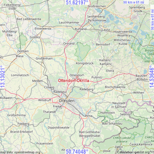
Ottendorf-Okrilla GPS coordinates[2]
51° 10' 59.988" North, 13° 49' 59.988" East
| Map corner | latitude | longitude |
|---|---|---|
| Upper-left | 51.62197°, | 13.13021° |
| Center: | 51.18333°, | 13.83333° |
| Lower-right: | 50.74048°, | 14.53646° |
| Map W x H: | 98×98 km | = 60.9×60.9mi |
| max Lat: | 55.01917° ⇑38.8% North |
| Ottendorf-Okrilla: | 51.18333° |
| min Lat: | ⇓61.2% South 47.40724° |
| min Long | Ottendorf-Okril | max Long |
| 5.92978° | 13.83333° | 14.98853° |
| W 97.4%⇐ | ⇒2.6% E |
Elevation
Elevation of Ottendorf-Okrilla is 176 m = 577 ft, and this is 73.1 m = 240 ft below average elevation for this country.
| Max E: |
1256 m = 4121 ft | 56.8% |
| Avg. | 249.1 m = 817 ft | |
| Ottendorf-Okrilla | 176 m = 577 ft | |
Min E: |
-5 m = -16 ft | 43.2% |
See also: Germany elevation on elevation.city.
Geographical zone
Ottendorf-Okrilla is located in North temperate zone (between Tropic of Cancer and the Arctic Circle). Distance of this North polar circle is 1710.1 km =1062.6 mi to North.| Distance of | km | miles | from Ottendorf-Okrilla |
|---|---|---|---|
| North Pole | 4316 | 2681.8 | to North |
| Arctic Circle | 1710.1 | 1062.6 | to North |
| Tropic Cancer | 3085.1 | 1917 | to South |
| Equator | 5691.1 | 3536.3 | to South |


Nearby cities:
15 places around Ottendorf-Okrilla: (largest is in red/bold)
• Albertstadt
12.1 km =7.5 mi,  202°
202°
• Ebersbach
13.9 km =8.6 mi,  293°
293°
• Feldschlößchen
7.6 km =4.7 mi,  130°
130°
• Großnaundorf
7.2 km =4.5 mi,  75°
75°
• Großröhrsdorf
13.6 km =8.5 mi,  108°
108°
• Höckendorf
7 km =4.3 mi,  49°
49°
• Königsbrück
10.3 km =6.4 mi,  29°
29°
• Laußnitz
8.2 km =5.1 mi, 25°
• Lichtenberg
9.3 km =5.8 mi,  90°
90°
• Moritzburg
11 km =6.8 mi,  255°
255°
• Oberlichtenau
11.6 km =7.2 mi,  70°
70°
• Radeberg
9.7 km =6 mi,  145°
145°
• Radeburg
8.1 km =5 mi,  295°
295°
• Tauscha
9.6 km =6 mi,  345°
345°
• Wachau
5.6 km =3.5 mi,  115°
115°
Sources, notices
• [Note1] Compared only with cities in Germany existing in our database
• [Src1] Map data: © OpenStreetMap contributors (CC-BY-SA)
• [Src2] Other city data from geonames.org with taken over terms of usage.
• [Src3] Geographical zone / Annual Mean Temperature by Robert A. Rohde @ Wikipedia
