Königsbrück geodata
Königsbrück (Saxony) is a populated place; located in Germany in Europe/Berlin (GMT+2) time zone. With population of 4,815 people, there are 2895 cities with bigger population in this country. Compared to other cities in Germany, 62.6% of cities are located further ↓South; 97.6% of cities are located further ←West and 56.5% of cities have higher elevation than Königsbrück. Note1


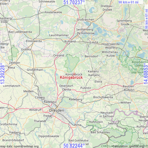
Königsbrück GPS coordinates[2]
51° 15' 52.236" North, 13° 54' 19.44" East
| Map corner | latitude | longitude |
|---|---|---|
| Upper-left | 51.70237°, | 13.20228° |
| Center: | 51.26451°, | 13.9054° |
| Lower-right: | 50.82244°, | 14.60853° |
| Map W x H: | 97.8×97.8 km | = 60.8×60.8mi |
| max Lat: | 55.01917° ⇑37.4% North |
| Königsbrück: | 51.26451° |
| min Lat: | ⇓62.6% South 47.40724° |
| min Long | Königsbrück | max Long |
| 5.92978° | 13.9054° | 14.98853° |
| W 97.6%⇐ | ⇒2.4% E |
Elevation
Elevation of Königsbrück is 178 m = 584 ft, and this is 71.1 m = 233 ft below average elevation for this country.
| Max E: |
1256 m = 4121 ft | 56.5% |
| Avg. | 249.1 m = 817 ft | |
| Königsbrück | 178 m = 584 ft | |
Min E: |
-5 m = -16 ft | 43.5% |
See also: Germany elevation on elevation.city.
Geographical zone
Königsbrück is located in North temperate zone (between Tropic of Cancer and the Arctic Circle). Distance of this North polar circle is 1701.1 km =1057 mi to North.| Distance of | km | miles | from Königsbrück |
|---|---|---|---|
| North Pole | 4307 | 2676.2 | to North |
| Arctic Circle | 1701.1 | 1057 | to North |
| Tropic Cancer | 3094.2 | 1922.6 | to South |
| Equator | 5700.1 | 3541.9 | to South |


Nearby cities:
15 places around Königsbrück: (largest is in red/bold)
• Großnaundorf
7.4 km =4.6 mi,  164°
164°
• Haselbachtal
9 km =5.6 mi,  110°
110°
• Höckendorf
4.5 km =2.8 mi,  176°
176°
• Kamenz
13.1 km =8.1 mi,  88°
88°
• Laußnitz
2.2 km =1.4 mi,  223°
223°
• Lichtenberg
10 km =6.2 mi,  154°
154°
• Neukirch
5.8 km =3.6 mi,  68°
68°
• Oberlichtenau
7.8 km =4.8 mi,  130°
130°
• Ottendorf-Okrilla
10.3 km =6.4 mi,  209°
209°
• Radeburg
13.5 km =8.4 mi,  246°
246°
• Schwepnitz
8 km =5 mi,  27°
27°
• Steina
12.4 km =7.7 mi, 125°
• Tauscha
7.3 km =4.5 mi,  271°
271°
• Thiendorf
11.9 km =7.4 mi,  285°
285°
• Wachau
11.4 km =7.1 mi, 179°
Sources, notices
• [Note1] Compared only with cities in Germany existing in our database
• [Src1] Map data: © OpenStreetMap contributors (CC-BY-SA)
• [Src2] Other city data from geonames.org with taken over terms of usage.
• [Src3] Geographical zone / Annual Mean Temperature by Robert A. Rohde @ Wikipedia
