Vreden geodata
Vreden (North Rhine-Westphalia) is a populated place; located in Germany in Europe/Berlin (GMT+1) time zone. With population of 22,412 people, there are 668 cities with bigger population in this country. Compared to other cities in Germany, 72.4% of cities are located further ↓South; 95.3% of cities are located further →East and 82.3% of cities have higher elevation than Vreden. Note1
Administrative division(s):
- Level 1: North Rhine-Westphalia
- Level 2: Regierungsbezirk Münster
- Level 3: Kreis Borken
- Level 4: Vreden


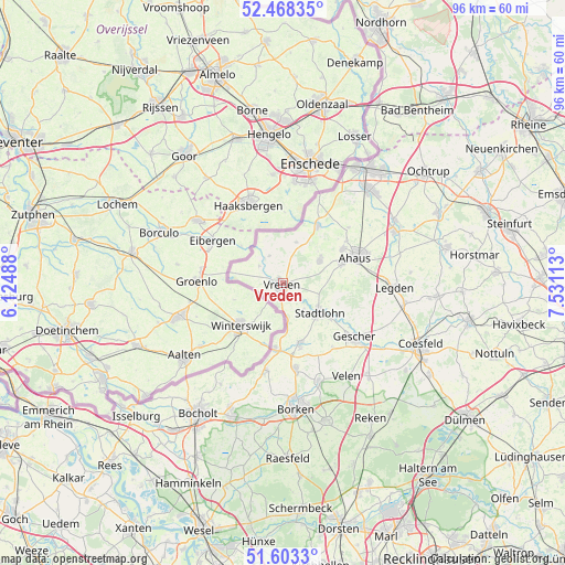
Vreden GPS coordinates[2]
52° 2' 16.512" North, 6° 49' 40.8" East
| Map corner | latitude | longitude |
|---|---|---|
| Upper-left | 52.46835°, | 6.12488° |
| Center: | 52.03792°, | 6.828° |
| Lower-right: | 51.6033°, | 7.53113° |
| Map W x H: | 96.2×96.2 km | = 59.8×59.8mi |
| max Lat: | 55.01917° ⇑27.6% North |
| Vreden: | 52.03792° |
| min Lat: | ⇓72.4% South 47.40724° |
| min Long | Vreden | max Long |
| 5.92978° | 6.828° | 14.98853° |
| W 4.7%⇐ | ⇒95.3% E |
Elevation
Elevation of Vreden is 41 m = 135 ft, and this is 208.1 m = 683 ft below average elevation for this country.
| Max E: |
1256 m = 4121 ft | 82.3% |
| Avg. | 249.1 m = 817 ft | |
| Vreden | 41 m = 135 ft | |
Min E: |
-5 m = -16 ft | 17.7% |
See also: Germany elevation on elevation.city.
Geographical zone
Vreden is located in North temperate zone (between Tropic of Cancer and the Arctic Circle). Distance of this North polar circle is 1615.1 km =1003.6 mi to North.| Distance of | km | miles | from Vreden |
|---|---|---|---|
| North Pole | 4221 | 2622.8 | to North |
| Arctic Circle | 1615.1 | 1003.6 | to North |
| Tropic Cancer | 3180.2 | 1976.1 | to South |
| Equator | 5786.1 | 3595.3 | to South |


Nearby cities:
15 places around Vreden: (largest is in red/bold)
• Ahaus
13.5 km =8.4 mi,  70°
70°
• Bocholt
26.5 km =16.5 mi,  213°
213°
• Borken
21.7 km =13.5 mi,  174°
174°
• Coesfeld
25.5 km =15.8 mi,  114°
114°
• Gescher
15.3 km =9.5 mi,  127°
127°
• Gronau
23.4 km =14.5 mi,  34°
34°
• Heek
20.5 km =12.7 mi,  64°
64°
• Heiden
23.9 km =14.9 mi,  162°
162°
• Legden
18.6 km =11.6 mi,  91°
91°
• Metelen
28.8 km =17.9 mi, 65°
• Rhede
24.3 km =15.1 mi,  201°
201°
• Schöppingen
28.6 km =17.8 mi,  76°
76°
• Stadtlohn
7.9 km =4.9 mi, 128°
• Südlohn
11.9 km =7.4 mi, 167°
• Velen
19.4 km =12.1 mi,  145°
145°
Sources, notices
• [Note1] Compared only with cities in Germany existing in our database
• [Src1] Map data: © OpenStreetMap contributors (CC-BY-SA)
• [Src2] Other city data from geonames.org with taken over terms of usage.
• [Src3] Geographical zone / Annual Mean Temperature by Robert A. Rohde @ Wikipedia
