Legden geodata
Legden (North Rhine-Westphalia) is a seat of a fourth-order administrative division; located in Germany in Europe/Berlin (GMT+2) time zone. With population of 6,725 people, there are 2250 cities with bigger population in this country. Compared to other cities in Germany, 72.3% of cities are located further ↓South; 92.4% of cities are located further →East and 73.4% of cities have higher elevation than Legden. Note1
Administrative division(s):
- Level 1: North Rhine-Westphalia
- Level 2: Regierungsbezirk Münster
- Level 3: Kreis Borken
- Level 4: Legden


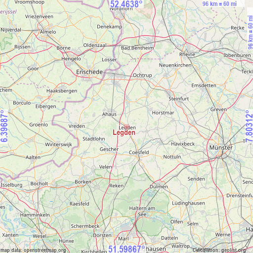
Legden GPS coordinates[2]
52° 1' 59.988" North, 7° 6' 0" East
| Map corner | latitude | longitude |
|---|---|---|
| Upper-left | 52.4638°, | 6.39687° |
| Center: | 52.03333°, | 7.1° |
| Lower-right: | 51.59867°, | 7.80312° |
| Map W x H: | 96.2×96.2 km | = 59.8×59.8mi |
| max Lat: | 55.01917° ⇑27.7% North |
| Legden: | 52.03333° |
| min Lat: | ⇓72.3% South 47.40724° |
| min Long | Legden | max Long |
| 5.92978° | 7.1° | 14.98853° |
| W 7.6%⇐ | ⇒92.4% E |
Elevation
Elevation of Legden is 70 m = 230 ft, and this is 179.1 m = 588 ft below average elevation for this country.
| Max E: |
1256 m = 4121 ft | 73.4% |
| Avg. | 249.1 m = 817 ft | |
| Legden | 70 m = 230 ft | |
Min E: |
-5 m = -16 ft | 26.6% |
See also: Germany elevation on elevation.city.
Geographical zone
Legden is located in North temperate zone (between Tropic of Cancer and the Arctic Circle). Distance of this North polar circle is 1615.6 km =1003.9 mi to North.| Distance of | km | miles | from Legden |
|---|---|---|---|
| North Pole | 4221.5 | 2623.1 | to North |
| Arctic Circle | 1615.6 | 1003.9 | to North |
| Tropic Cancer | 3179.6 | 1975.7 | to South |
| Equator | 5785.6 | 3595 | to South |


Nearby cities:
15 places around Legden: (largest is in red/bold)
• Ahaus
7.8 km =4.8 mi,  310°
310°
• Billerbeck
14.5 km =9 mi,  114°
114°
• Coesfeld
11 km =6.8 mi,  154°
154°
• Gescher
11 km =6.8 mi,  216°
216°
• Heek
9.3 km =5.8 mi,  0°
0°
• Horstmar
15 km =9.3 mi,  69°
69°
• Laer
17.8 km =11.1 mi,  82°
82°
• Metelen
14.5 km =9 mi,  31°
31°
• Nottuln
20.4 km =12.7 mi,  123°
123°
• Ochtrup
20.4 km =12.7 mi,  17°
17°
• Schöppingen
11.7 km =7.3 mi,  50°
50°
• Stadtlohn
13.1 km =8.1 mi,  250°
250°
• Südlohn
19.5 km =12.1 mi,  235°
235°
• Velen
17.2 km =10.7 mi,  206°
206°
• Vreden
18.6 km =11.6 mi,  271°
271°
Sources, notices
• [Note1] Compared only with cities in Germany existing in our database
• [Src1] Map data: © OpenStreetMap contributors (CC-BY-SA)
• [Src2] Other city data from geonames.org with taken over terms of usage.
• [Src3] Geographical zone / Annual Mean Temperature by Robert A. Rohde @ Wikipedia
