Velen geodata
Velen (North Rhine-Westphalia) is a seat of a fourth-order administrative division; located in Germany in Europe/Berlin (GMT+2) time zone. With population of 13,074 people, there are 1232 cities with bigger population in this country. Compared to other cities in Germany, 71% of cities are located further ↓South; 93.5% of cities are located further →East and 75.8% of cities have higher elevation than Velen. Note1
Administrative division(s):
- Level 1: North Rhine-Westphalia
- Level 2: Regierungsbezirk Münster
- Level 3: Kreis Borken
- Level 4: Velen


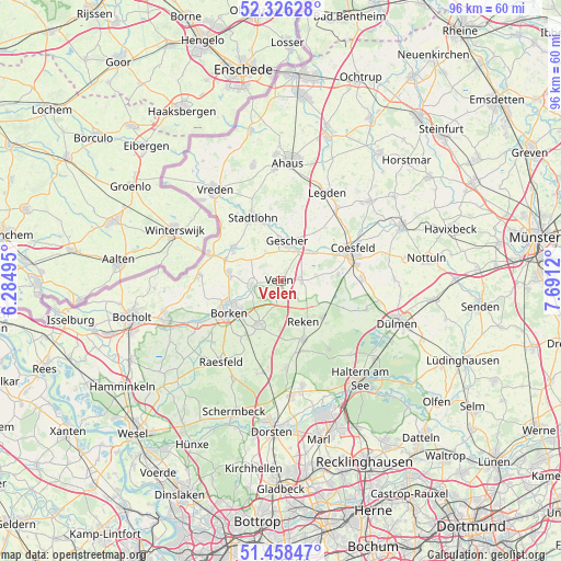
Velen GPS coordinates[2]
51° 53' 40.092" North, 6° 59' 17.052" East
| Map corner | latitude | longitude |
|---|---|---|
| Upper-left | 52.32628°, | 6.28495° |
| Center: | 51.89447°, | 6.98807° |
| Lower-right: | 51.45847°, | 7.6912° |
| Map W x H: | 96.5×96.5 km | = 60×60mi |
| max Lat: | 55.01917° ⇑29% North |
| Velen: | 51.89447° |
| min Lat: | ⇓71% South 47.40724° |
| min Long | Velen | max Long |
| 5.92978° | 6.98807° | 14.98853° |
| W 6.5%⇐ | ⇒93.5% E |
Elevation
Elevation of Velen is 60 m = 197 ft, and this is 189.1 m = 620 ft below average elevation for this country.
| Max E: |
1256 m = 4121 ft | 75.8% |
| Avg. | 249.1 m = 817 ft | |
| Velen | 60 m = 197 ft | |
Min E: |
-5 m = -16 ft | 24.2% |
See also: Germany elevation on elevation.city.
Geographical zone
Velen is located in North temperate zone (between Tropic of Cancer and the Arctic Circle). Distance of this North polar circle is 1631 km =1013.5 mi to North.| Distance of | km | miles | from Velen |
|---|---|---|---|
| North Pole | 4236.9 | 2632.7 | to North |
| Arctic Circle | 1631 | 1013.5 | to North |
| Tropic Cancer | 3164.2 | 1966.1 | to South |
| Equator | 5770.1 | 3585.4 | to South |


Nearby cities:
15 places around Velen: (largest is in red/bold)
• Ahaus
20.6 km =12.8 mi,  4°
4°
• Billerbeck
22.9 km =14.2 mi,  65°
65°
• Borken
10.6 km =6.6 mi,  237°
237°
• Coesfeld
13.5 km =8.4 mi, 66°
• Dülmen
21.3 km =13.2 mi,  109°
109°
• Gescher
6.7 km =4.2 mi,  9°
9°
• Haltern am See
21.5 km =13.4 mi,  141°
141°
• Heiden
7.8 km =4.8 mi,  208°
208°
• Klein Reken
12.5 km =7.8 mi,  162°
162°
• Legden
17.2 km =10.7 mi,  26°
26°
• Raesfeld
17.1 km =10.6 mi, 213°
• Rhede
21.1 km =13.1 mi,  251°
251°
• Stadtlohn
12 km =7.5 mi,  336°
336°
• Südlohn
9.4 km =5.8 mi,  297°
297°
• Vreden
19.4 km =12.1 mi,  325°
325°
Sources, notices
• [Note1] Compared only with cities in Germany existing in our database
• [Src1] Map data: © OpenStreetMap contributors (CC-BY-SA)
• [Src2] Other city data from geonames.org with taken over terms of usage.
• [Src3] Geographical zone / Annual Mean Temperature by Robert A. Rohde @ Wikipedia
