Metelen geodata
Metelen (North Rhine-Westphalia) is a seat of a fourth-order administrative division; located in Germany in Europe/Berlin (GMT+2) time zone. With population of 6,490 people, there are 2310 cities with bigger population in this country. Compared to other cities in Germany, 73.5% of cities are located further ↓South; 91.2% of cities are located further →East and 76.1% of cities have higher elevation than Metelen. Note1
Administrative division(s):
- Level 1: North Rhine-Westphalia
- Level 2: Regierungsbezirk Münster
- Level 3: Kreis Steinfurt
- Level 4: Metelen


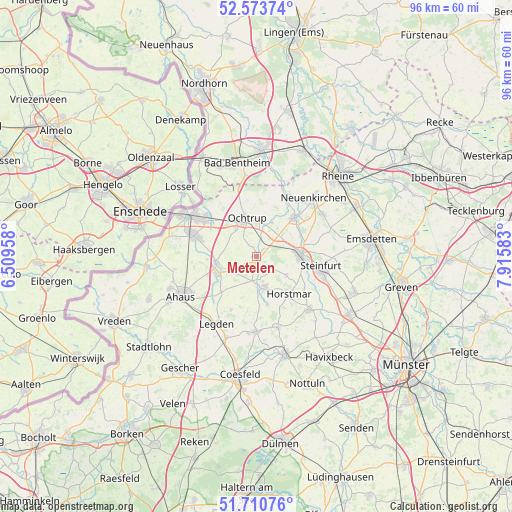
Metelen GPS coordinates[2]
52° 8' 39.624" North, 7° 12' 45.72" East
| Map corner | latitude | longitude |
|---|---|---|
| Upper-left | 52.57374°, | 6.50958° |
| Center: | 52.14434°, | 7.2127° |
| Lower-right: | 51.71076°, | 7.91583° |
| Map W x H: | 96×96 km | = 59.7×59.7mi |
| max Lat: | 55.01917° ⇑26.5% North |
| Metelen: | 52.14434° |
| min Lat: | ⇓73.5% South 47.40724° |
| min Long | Metelen | max Long |
| 5.92978° | 7.2127° | 14.98853° |
| W 8.8%⇐ | ⇒91.2% E |
Elevation
Elevation of Metelen is 59 m = 194 ft, and this is 190.1 m = 624 ft below average elevation for this country.
| Max E: |
1256 m = 4121 ft | 76.1% |
| Avg. | 249.1 m = 817 ft | |
| Metelen | 59 m = 194 ft | |
Min E: |
-5 m = -16 ft | 23.9% |
See also: Germany elevation on elevation.city.
Geographical zone
Metelen is located in North temperate zone (between Tropic of Cancer and the Arctic Circle). Distance of this North polar circle is 1603.3 km =996.2 mi to North.| Distance of | km | miles | from Metelen |
|---|---|---|---|
| North Pole | 4209.2 | 2615.5 | to North |
| Arctic Circle | 1603.3 | 996.2 | to North |
| Tropic Cancer | 3192 | 1983.4 | to South |
| Equator | 5797.9 | 3602.6 | to South |


Nearby cities:
15 places around Metelen: (largest is in red/bold)
• Ahaus
15.4 km =9.6 mi,  242°
242°
• Bad Bentheim
17.8 km =11.1 mi,  347°
347°
• Gronau
14.9 km =9.3 mi,  299°
299°
• Heek
8.3 km =5.2 mi,  248°
248°
• Horstmar
9.5 km =5.9 mi,  138°
138°
• Laer
14 km =8.7 mi,  134°
134°
• Legden
14.5 km =9 mi,  211°
211°
• Neuenkirchen
15.6 km =9.7 mi,  44°
44°
• Ochtrup
7.2 km =4.5 mi, 347°
• Ohne
14.4 km =8.9 mi,  19°
19°
• Samern
17.4 km =10.8 mi,  11°
11°
• Schöppingen
5.1 km =3.2 mi,  164°
164°
• Steinfurt
8.5 km =5.3 mi,  85°
85°
• Suddendorf
17.4 km =10.8 mi,  2°
2°
• Wettringen
10.2 km =6.3 mi,  45°
45°
Sources, notices
• [Note1] Compared only with cities in Germany existing in our database
• [Src1] Map data: © OpenStreetMap contributors (CC-BY-SA)
• [Src2] Other city data from geonames.org with taken over terms of usage.
• [Src3] Geographical zone / Annual Mean Temperature by Robert A. Rohde @ Wikipedia
