Voerde geodata
Voerde (North Rhine-Westphalia) is a populated place; located in Germany in Europe/Berlin (GMT+2) time zone. With population of 38,759 people, there are 336 cities with bigger population in this country. Compared to other cities in Germany, 67.6% of cities are located further ↓South; 96.5% of cities are located further →East and 88% of cities have higher elevation than Voerde. Note1
Administrative division(s):
- Level 1: North Rhine-Westphalia
- Level 2: Düsseldorf District
- Level 3: Kreis Wesel
- Level 4: Voerde (Niederrhein)


Voerde GPS coordinates[2]
51° 35' 49.308" North, 6° 41' 10.68" East
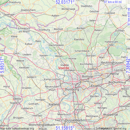
| Map corner | latitude | longitude |
|---|---|---|
| Upper-left | 52.03171°, | 5.98317° |
| Center: | 51.59703°, | 6.6863° |
| Lower-right: | 51.15815°, | 7.38942° |
| Map W x H: | 97.1×97.1 km | = 60.3×60.3mi |
| max Lat: | 55.01917° ⇑32.4% North |
| Voerde: | 51.59703° |
| min Lat: | ⇓67.6% South 47.40724° |
| min Long | Voerde | max Long |
| 5.92978° | 6.6863° | 14.98853° |
| W 3.5%⇐ | ⇒96.5% E |
Elevation
Elevation of Voerde is 27 m = 89 ft, and this is 222.1 m = 729 ft below average elevation for this country.
| Max E: |
1256 m = 4121 ft | 88% |
| Avg. | 249.1 m = 817 ft | |
| Voerde | 27 m = 89 ft | |
Min E: |
-5 m = -16 ft | 12% |
See also: Germany elevation on elevation.city.
Geographical zone
Voerde is located in North temperate zone (between Tropic of Cancer and the Arctic Circle). Distance of this North polar circle is 1664.1 km =1034 mi to North.| Distance of | km | miles | from Voerde |
|---|---|---|---|
| North Pole | 4270 | 2653.3 | to North |
| Arctic Circle | 1664.1 | 1034 | to North |
| Tropic Cancer | 3131.1 | 1945.6 | to South |
| Equator | 5737.1 | 3564.9 | to South |


Nearby cities:
15 places around Voerde: (largest is in red/bold)
• Alpen
11.8 km =7.3 mi,  262°
262°
• Bottrop
18.6 km =11.6 mi,  115°
115°
• Dinslaken
5.5 km =3.4 mi,  134°
134°
• Duisburg
19.1 km =11.9 mi,  163°
163°
• Hamminkeln
16.5 km =10.3 mi,  336°
336°
• Hünxe
4.2 km =2.6 mi,  10°
10°
• Issum
18.9 km =11.7 mi,  247°
247°
• Kamp-Lintfort
14.1 km =8.8 mi,  223°
223°
• Meiderich
15.5 km =9.6 mi, 159°
• Moers
16.4 km =10.2 mi,  193°
193°
• Oberhausen
18 km =11.2 mi,  137°
137°
• Rheinberg
8.4 km =5.2 mi,  228°
228°
• Schermbeck
15.7 km =9.8 mi,  52°
52°
• Wesel
9 km =5.6 mi,  329°
329°
• Xanten
17.5 km =10.9 mi,  293°
293°
Sources, notices
• [Note1] Compared only with cities in Germany existing in our database
• [Src1] Map data: © OpenStreetMap contributors (CC-BY-SA)
• [Src2] Other city data from geonames.org with taken over terms of usage.
• [Src3] Geographical zone / Annual Mean Temperature by Robert A. Rohde @ Wikipedia
