Eging geodata
Eging (Bavaria) is a populated place; located in Germany in Europe/Berlin (GMT+2) time zone. With population of 3,876 people, there are 3362 cities with bigger population in this country. Compared to other cities in Germany, 89.5% of cities are located further ↑North; 84.5% of cities are located further ←West and 86% of cities have lower elevation than Eging. Note1
Administrative division(s):
- Level 1: Bavaria
- Level 2: Lower Bavaria
- Level 3: Landkreis Landshut
- Level 4: Altfraunhofen


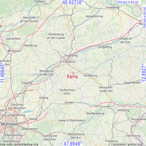
Eging GPS coordinates[2]
48° 27' 47.808" North, 12° 11' 22.452" East
| Map corner | latitude | longitude |
|---|---|---|
| Upper-left | 48.92738°, | 11.48645° |
| Center: | 48.46328°, | 12.18957° |
| Lower-right: | 47.9949°, | 12.8927° |
| Map W x H: | 103.7×103.7 km | = 64.4×64.4mi |
| max Lat: | 55.01917° ⇑89.5% North |
| Eging: | 48.46328° |
| min Lat: | ⇓10.5% South 47.40724° |
| min Long | Eging | max Long |
| 5.92978° | 12.18957° | 14.98853° |
| W 84.5%⇐ | ⇒15.5% E |
Elevation
Elevation of Eging is 478 m = 1568 ft, and this is 228.9 m = 751 ft above average elevation for this country.
| Max E: |
1256 m = 4121 ft | 14% |
| Eging | 478 m 1568 ft | |
| Avg. | 249.1 m = 817 ft | |
Min E: |
-5 m = -16 ft | 86% |
See also: Germany elevation on elevation.city.
Geographical zone
Eging is located in North temperate zone (between Tropic of Cancer and the Arctic Circle). Distance of this North polar circle is 2012.6 km =1250.6 mi to North.| Distance of | km | miles | from Eging |
|---|---|---|---|
| North Pole | 4618.5 | 2869.8 | to North |
| Arctic Circle | 2012.6 | 1250.6 | to North |
| Tropic Cancer | 2782.7 | 1729.1 | to South |
| Equator | 5388.6 | 3348.3 | to South |


Nearby cities:
15 places around Eging: (largest is in red/bold)
• Adlkofen
11.2 km =7 mi,  30°
30°
• Altfraunhofen
2.2 km =1.4 mi,  228°
228°
• Baierbach
5.2 km =3.2 mi,  171°
171°
• Eching
9.9 km =6.2 mi,  294°
294°
• Geisenhausen
5.3 km =3.3 mi,  74°
74°
• Hohenpolding
9.8 km =6.1 mi,  205°
205°
• Kumhausen
5.7 km =3.5 mi,  334°
334°
• Landshut
7.7 km =4.8 mi,  344°
344°
• Neufraunhofen
7.3 km =4.5 mi,  164°
164°
• Stallwang
11 km =6.8 mi,  16°
16°
• Steinkirchen
11.9 km =7.4 mi,  221°
221°
• Tiefenbach
7.8 km =4.8 mi,  301°
301°
• Velden
11.8 km =7.3 mi, 155°
• Vilsbiburg
12.3 km =7.6 mi,  95°
95°
• Vilsheim
6.3 km =3.9 mi,  255°
255°
Sources, notices
• [Note1] Compared only with cities in Germany existing in our database
• [Src1] Map data: © OpenStreetMap contributors (CC-BY-SA)
• [Src2] Other city data from geonames.org with taken over terms of usage.
• [Src3] Geographical zone / Annual Mean Temperature by Robert A. Rohde @ Wikipedia
