Viernheim geodata
Viernheim (Hesse) is a populated place; located in Germany in Europe/Berlin (GMT+2) time zone. With population of 32,620 people, there are 420 cities with bigger population in this country. Compared to other cities in Germany, 74.9% of cities are located further ↑North; 70.4% of cities are located further →East and 67.8% of cities have higher elevation than Viernheim. Note1
Administrative division(s):
- Level 1: Hesse
- Level 2: Regierungsbezirk Darmstadt
- Level 3: Landkreis Bergstraße
- Level 4: Viernheim


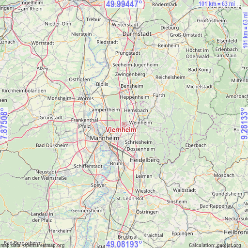
Viernheim GPS coordinates[2]
49° 32' 25.188" North, 8° 34' 41.52" East
| Map corner | latitude | longitude |
|---|---|---|
| Upper-left | 49.99447°, | 7.87508° |
| Center: | 49.54033°, | 8.5782° |
| Lower-right: | 49.08193°, | 9.28133° |
| Map W x H: | 101.5×101.5 km | = 63.1×63.1mi |
| max Lat: | 55.01917° ⇑74.9% North |
| Viernheim: | 49.54033° |
| min Lat: | ⇓25.1% South 47.40724° |
| min Long | Viernheim | max Long |
| 5.92978° | 8.5782° | 14.98853° |
| W 29.6%⇐ | ⇒70.4% E |
Elevation
Elevation of Viernheim is 103 m = 338 ft, and this is 146.1 m = 479 ft below average elevation for this country.
| Max E: |
1256 m = 4121 ft | 67.8% |
| Avg. | 249.1 m = 817 ft | |
| Viernheim | 103 m = 338 ft | |
Min E: |
-5 m = -16 ft | 32.2% |
See also: Germany elevation on elevation.city.
Geographical zone
Viernheim is located in North temperate zone (between Tropic of Cancer and the Arctic Circle). Distance of this North polar circle is 1892.8 km =1176.1 mi to North.| Distance of | km | miles | from Viernheim |
|---|---|---|---|
| North Pole | 4498.7 | 2795.4 | to North |
| Arctic Circle | 1892.8 | 1176.1 | to North |
| Tropic Cancer | 2902.4 | 1803.5 | to South |
| Equator | 5508.4 | 3422.8 | to South |


Nearby cities:
15 places around Viernheim: (largest is in red/bold)
• Birkenau
9.6 km =6 mi,  75°
75°
• Dossenheim
12.2 km =7.6 mi,  145°
145°
• Edingen-Neckarhausen
9.5 km =5.9 mi,  167°
167°
• Heddesheim
4.3 km =2.7 mi, 154°
• Hemsbach
7.5 km =4.7 mi,  41°
41°
• Heppenheim an der Bergstrasse
11.9 km =7.4 mi,  19°
19°
• Hirschberg an der Bergstraße
6.8 km =4.2 mi,  123°
123°
• Ilvesheim
7.4 km =4.6 mi,  186°
186°
• Ladenburg
7.8 km =4.8 mi,  163°
163°
• Lampertheim
10 km =6.2 mi,  310°
310°
• Laudenbach
9.8 km =6.1 mi,  33°
33°
• Ludwigshafen am Rhein
11.6 km =7.2 mi,  235°
235°
• Mannheim
9.8 km =6.1 mi,  234°
234°
• Schriesheim
9.6 km =6 mi,  140°
140°
• Weinheim
6.5 km =4 mi, 81°
Sources, notices
• [Note1] Compared only with cities in Germany existing in our database
• [Src1] Map data: © OpenStreetMap contributors (CC-BY-SA)
• [Src2] Other city data from geonames.org with taken over terms of usage.
• [Src3] Geographical zone / Annual Mean Temperature by Robert A. Rohde @ Wikipedia
