Heppenheim an der Bergstrasse geodata
Heppenheim an der Bergstrasse (Hesse) is a seat of a third-order administrative division; located in Germany in Europe/Berlin (GMT+2) time zone. With population of 25,442 people, there are 574 cities with bigger population in this country. Compared to other cities in Germany, 72.7% of cities are located further ↑North; 69.8% of cities are located further →East and 67.8% of cities have higher elevation than Heppenheim an der Bergstrasse. Note1
Administrative division(s):
- Level 1: Hesse
- Level 2: Regierungsbezirk Darmstadt
- Level 3: Landkreis Bergstraße
- Level 4: Heppenheim (Bergstraße), Kreisstadt
Current local time in Heppenheim an der Bergstrasse:
01:14 PM, TuesdayDifference from your time zone: hours


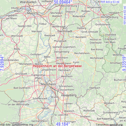
Heppenheim an der Bergstrasse GPS coordinates[2]
49° 38' 29.22" North, 8° 37' 55.416" East
| Map corner | latitude | longitude |
|---|---|---|
| Upper-left | 50.09464°, | 7.92894° |
| Center: | 49.64145°, | 8.63206° |
| Lower-right: | 49.184°, | 9.33519° |
| Map W x H: | 101.3×101.3 km | = 62.9×62.9mi |
| max Lat: | 55.01917° ⇑72.7% North |
| Heppenheim an der Bergstrasse: | 49.64145° |
| min Lat: | ⇓27.3% South 47.40724° |
| min Long | Heppenheim an d | max Long |
| 5.92978° | 8.63206° | 14.98853° |
| W 30.2%⇐ | ⇒69.8% E |
Elevation
Elevation of Heppenheim an der Bergstrasse is 103 m = 338 ft, and this is 146.1 m = 479 ft below average elevation for this country.
| Max E: |
1256 m = 4121 ft | 67.8% |
| Avg. | 249.1 m = 817 ft | |
| Heppenheim an der Bergstrasse | 103 m = 338 ft | |
Min E: |
-5 m = -16 ft | 32.2% |
See also: Germany elevation on elevation.city.
Geographical zone
Heppenheim an der Bergstrasse is located in North temperate zone (between Tropic of Cancer and the Arctic Circle). Distance of this North polar circle is 1881.6 km =1169.2 mi to North.| Distance of | km | miles | from Heppenheim an der Bergstrasse |
|---|---|---|---|
| North Pole | 4487.5 | 2788.4 | to North |
| Arctic Circle | 1881.6 | 1169.2 | to North |
| Tropic Cancer | 2913.7 | 1810.5 | to South |
| Equator | 5519.6 | 3429.7 | to South |


Nearby cities:
15 places around Heppenheim an der Bergstrasse: (largest is in red/bold)
• Alsbach-Hähnlein
11.1 km =6.9 mi,  346°
346°
• Bensheim
4.8 km =3 mi, 348°
• Birkenau
10.3 km =6.4 mi,  148°
148°
• Bürstadt
12.4 km =7.7 mi,  270°
270°
• Einhausen
7.2 km =4.5 mi,  303°
303°
• Fürth
11 km =6.8 mi,  84°
84°
• Hemsbach
5.8 km =3.6 mi,  168°
168°
• Laudenbach
3.5 km =2.2 mi, 153°
• Lindenfels
11.7 km =7.3 mi,  66°
66°
• Lorsch
4.8 km =3 mi,  281°
281°
• Mörlenbach
8.8 km =5.5 mi,  122°
122°
• Rimbach
9.6 km =6 mi,  100°
100°
• Viernheim
11.9 km =7.4 mi,  199°
199°
• Weinheim
10.6 km =6.6 mi, 166°
• Zwingenberg
9.3 km =5.8 mi, 350°
Sources, notices
• [Note1] Compared only with cities in Germany existing in our database
• [Src1] Map data: © OpenStreetMap contributors (CC-BY-SA)
• [Src2] Other city data from geonames.org with taken over terms of usage.
• [Src3] Geographical zone / Annual Mean Temperature by Robert A. Rohde @ Wikipedia
