Hemsbach geodata
Hemsbach (Baden-Württemberg) is a populated place; located in Germany in Europe/Berlin (GMT+2) time zone. With population of 12,247 people, there are 1336 cities with bigger population in this country. Compared to other cities in Germany, 74% of cities are located further ↑North; 69.6% of cities are located further →East and 68.3% of cities have higher elevation than Hemsbach. Note1
Administrative division(s):
- Level 1: Baden-Württemberg
- Level 2: Karlsruhe Region
- Level 3: Rhein-Neckar-Kreis
- Level 4: Hemsbach


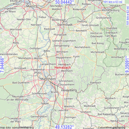
Hemsbach GPS coordinates[2]
49° 35' 26.7" North, 8° 38' 52.044" East
| Map corner | latitude | longitude |
|---|---|---|
| Upper-left | 50.04442°, | 7.94466° |
| Center: | 49.59075°, | 8.64779° |
| Lower-right: | 49.13282°, | 9.35091° |
| Map W x H: | 101.4×101.4 km | = 63×63mi |
| max Lat: | 55.01917° ⇑74% North |
| Hemsbach: | 49.59075° |
| min Lat: | ⇓26% South 47.40724° |
| min Long | Hemsbach | max Long |
| 5.92978° | 8.64779° | 14.98853° |
| W 30.4%⇐ | ⇒69.6% E |
Elevation
Elevation of Hemsbach is 101 m = 331 ft, and this is 148.1 m = 486 ft below average elevation for this country.
| Max E: |
1256 m = 4121 ft | 68.3% |
| Avg. | 249.1 m = 817 ft | |
| Hemsbach | 101 m = 331 ft | |
Min E: |
-5 m = -16 ft | 31.7% |
See also: Germany elevation on elevation.city.
Geographical zone
Hemsbach is located in North temperate zone (between Tropic of Cancer and the Arctic Circle). Distance of this North polar circle is 1887.2 km =1172.7 mi to North.| Distance of | km | miles | from Hemsbach |
|---|---|---|---|
| North Pole | 4493.1 | 2791.9 | to North |
| Arctic Circle | 1887.2 | 1172.7 | to North |
| Tropic Cancer | 2908.1 | 1807 | to South |
| Equator | 5514 | 3426.2 | to South |


Nearby cities:
15 places around Hemsbach: (largest is in red/bold)
• Bensheim
10.5 km =6.5 mi,  348°
348°
• Birkenau
5.3 km =3.3 mi,  126°
126°
• Einhausen
11.9 km =7.4 mi,  323°
323°
• Fürth
11.9 km =7.4 mi,  55°
55°
• Heddesheim
10 km =6.2 mi,  198°
198°
• Heppenheim an der Bergstrasse
5.8 km =3.6 mi, 348°
• Hirschberg an der Bergstraße
9.3 km =5.8 mi,  175°
175°
• Lampertheim
12.7 km =7.9 mi,  273°
273°
• Laudenbach
2.5 km =1.6 mi,  9°
9°
• Lorsch
8.8 km =5.5 mi, 318°
• Mörlenbach
6.3 km =3.9 mi,  81°
81°
• Rimbach
9.1 km =5.7 mi,  65°
65°
• Unter-Abtsteinach
12.3 km =7.6 mi, 125°
• Viernheim
7.5 km =4.7 mi,  221°
221°
• Weinheim
4.9 km =3 mi,  163°
163°
Sources, notices
• [Note1] Compared only with cities in Germany existing in our database
• [Src1] Map data: © OpenStreetMap contributors (CC-BY-SA)
• [Src2] Other city data from geonames.org with taken over terms of usage.
• [Src3] Geographical zone / Annual Mean Temperature by Robert A. Rohde @ Wikipedia
