Lampertheim geodata
Lampertheim (Hesse) is a populated place; located in Germany in Europe/Berlin (GMT+2) time zone. With population of 31,635 people, there are 437 cities with bigger population in this country. Compared to other cities in Germany, 73.9% of cities are located further ↑North; 71.3% of cities are located further →East and 69% of cities have higher elevation than Lampertheim. Note1
Administrative division(s):
- Level 1: Hesse
- Level 2: Regierungsbezirk Darmstadt
- Level 3: Landkreis Bergstraße
- Level 4: Lampertheim


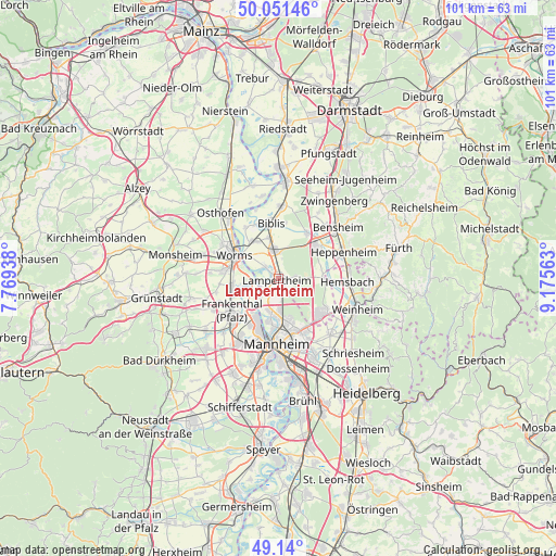
Lampertheim GPS coordinates[2]
49° 35' 52.296" North, 8° 28' 21" East
| Map corner | latitude | longitude |
|---|---|---|
| Upper-left | 50.05146°, | 7.76938° |
| Center: | 49.59786°, | 8.4725° |
| Lower-right: | 49.14°, | 9.17563° |
| Map W x H: | 101.3×101.3 km | = 62.9×62.9mi |
| max Lat: | 55.01917° ⇑73.9% North |
| Lampertheim: | 49.59786° |
| min Lat: | ⇓26.1% South 47.40724° |
| min Long | Lampertheim | max Long |
| 5.92978° | 8.4725° | 14.98853° |
| W 28.7%⇐ | ⇒71.3% E |
Elevation
Elevation of Lampertheim is 97 m = 318 ft, and this is 152.1 m = 499 ft below average elevation for this country.
| Max E: |
1256 m = 4121 ft | 69% |
| Avg. | 249.1 m = 817 ft | |
| Lampertheim | 97 m = 318 ft | |
Min E: |
-5 m = -16 ft | 31% |
See also: Germany elevation on elevation.city.
Geographical zone
Lampertheim is located in North temperate zone (between Tropic of Cancer and the Arctic Circle). Distance of this North polar circle is 1886.4 km =1172.2 mi to North.| Distance of | km | miles | from Lampertheim |
|---|---|---|---|
| North Pole | 4492.3 | 2791.4 | to North |
| Arctic Circle | 1886.4 | 1172.2 | to North |
| Tropic Cancer | 2908.8 | 1807.4 | to South |
| Equator | 5514.8 | 3426.7 | to South |


Nearby cities:
15 places around Lampertheim: (largest is in red/bold)
• Beindersheim
11.8 km =7.3 mi,  249°
249°
• Biblis
10.5 km =6.5 mi,  354°
354°
• Bobenheim-Roxheim
8.3 km =5.2 mi,  262°
262°
• Bürstadt
5.1 km =3.2 mi, 349°
• Einhausen
10.3 km =6.4 mi,  31°
31°
• Frankenthal
11.1 km =6.9 mi,  230°
230°
• Großniedesheim
11.8 km =7.3 mi, 257°
• Hemsbach
12.7 km =7.9 mi,  93°
93°
• Heppenheim an der Bergstrasse
12.5 km =7.8 mi,  67°
67°
• Kleinniedesheim
10.9 km =6.8 mi, 263°
• Lorsch
8.9 km =5.5 mi,  49°
49°
• Ludwigshafen am Rhein
13.1 km =8.1 mi,  188°
188°
• Mannheim
12.1 km =7.5 mi,  181°
181°
• Viernheim
10 km =6.2 mi,  130°
130°
• Worms
9 km =5.6 mi,  295°
295°
Sources, notices
• [Note1] Compared only with cities in Germany existing in our database
• [Src1] Map data: © OpenStreetMap contributors (CC-BY-SA)
• [Src2] Other city data from geonames.org with taken over terms of usage.
• [Src3] Geographical zone / Annual Mean Temperature by Robert A. Rohde @ Wikipedia
