Hebertshausen geodata
Hebertshausen (Bavaria) is a seat of a fourth-order administrative division; located in Germany in Europe/Berlin (GMT+2) time zone. With population of 5,121 people, there are 2779 cities with bigger population in this country. Compared to other cities in Germany, 91.4% of cities are located further ↑North; 73.7% of cities are located further ←West and 86.3% of cities have lower elevation than Hebertshausen. Note1
Administrative division(s):
- Level 1: Bavaria
- Level 2: Upper Bavaria
- Level 3: Landkreis Dachau
- Level 4: Hebertshausen


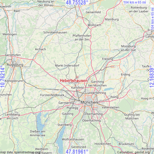
Hebertshausen GPS coordinates[2]
48° 17' 22.524" North, 11° 27' 54.936" East
| Map corner | latitude | longitude |
|---|---|---|
| Upper-left | 48.75528°, | 10.76214° |
| Center: | 48.28959°, | 11.46526° |
| Lower-right: | 47.81961°, | 12.16839° |
| Map W x H: | 104×104 km | = 64.6×64.6mi |
| max Lat: | 55.01917° ⇑91.4% North |
| Hebertshausen: | 48.28959° |
| min Lat: | ⇓8.6% South 47.40724° |
| min Long | Hebertshausen | max Long |
| 5.92978° | 11.46526° | 14.98853° |
| W 73.7%⇐ | ⇒26.3% E |
Elevation
Elevation of Hebertshausen is 480 m = 1575 ft, and this is 230.9 m = 758 ft above average elevation for this country.
| Max E: |
1256 m = 4121 ft | 13.7% |
| Hebertshausen | 480 m 1575 ft | |
| Avg. | 249.1 m = 817 ft | |
Min E: |
-5 m = -16 ft | 86.3% |
See also: Germany elevation on elevation.city.
Geographical zone
Hebertshausen is located in North temperate zone (between Tropic of Cancer and the Arctic Circle). Distance of this North polar circle is 2031.9 km =1262.6 mi to North.| Distance of | km | miles | from Hebertshausen |
|---|---|---|---|
| North Pole | 4637.8 | 2881.8 | to North |
| Arctic Circle | 2031.9 | 1262.6 | to North |
| Tropic Cancer | 2763.4 | 1717.1 | to South |
| Equator | 5369.3 | 3336.3 | to South |


Nearby cities:
15 places around Hebertshausen: (largest is in red/bold)
• Bergkirchen
8.3 km =5.2 mi,  243°
243°
• Dachau
4 km =2.5 mi,  215°
215°
• Eching
11.3 km =7 mi,  84°
84°
• Erdweg
12.9 km =8 mi,  291°
291°
• Fahrenzhausen
9.7 km =6 mi,  43°
43°
• Gröbenzell
12.4 km =7.7 mi, 216°
• Haimhausen
7.2 km =4.5 mi,  66°
66°
• Karlsfeld
7 km =4.3 mi,  173°
173°
• Markt Indersdorf
10.2 km =6.3 mi,  320°
320°
• Oberschleißheim
8.7 km =5.4 mi,  120°
120°
• Röhrmoos
4.7 km =2.9 mi,  342°
342°
• Schwabhausen
8.2 km =5.1 mi,  280°
280°
• Unterschleißheim
8.3 km =5.2 mi,  97°
97°
• Vierkirchen
8.6 km =5.3 mi,  0°
0°
• Weichs
11 km =6.8 mi, 340°
Sources, notices
• [Note1] Compared only with cities in Germany existing in our database
• [Src1] Map data: © OpenStreetMap contributors (CC-BY-SA)
• [Src2] Other city data from geonames.org with taken over terms of usage.
• [Src3] Geographical zone / Annual Mean Temperature by Robert A. Rohde @ Wikipedia
