Dachau geodata
Dachau (Bavaria) is a seat of a third-order administrative division; located in Germany in Europe/Berlin (GMT+2) time zone. With population of 39,740 people, there are 323 cities with bigger population in this country. Compared to other cities in Germany, 91.8% of cities are located further ↑North; 73.2% of cities are located further ←West and 88.8% of cities have lower elevation than Dachau. Note1
Administrative division(s):
- Level 1: Bavaria
- Level 2: Upper Bavaria
- Level 3: Landkreis Dachau
- Level 4: Dachau


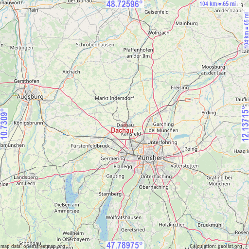
Dachau GPS coordinates[2]
48° 15' 36" North, 11° 26' 2.472" East
| Map corner | latitude | longitude |
|---|---|---|
| Upper-left | 48.72596°, | 10.7309° |
| Center: | 48.26°, | 11.43402° |
| Lower-right: | 47.78975°, | 12.13715° |
| Map W x H: | 104.1×104.1 km | = 64.7×64.7mi |
| max Lat: | 55.01917° ⇑91.8% North |
| Dachau: | 48.26° |
| min Lat: | ⇓8.2% South 47.40724° |
| min Long | Dachau | max Long |
| 5.92978° | 11.43402° | 14.98853° |
| W 73.2%⇐ | ⇒26.8% E |
Elevation
Elevation of Dachau is 502 m = 1647 ft, and this is 252.9 m = 830 ft above average elevation for this country.
| Max E: |
1256 m = 4121 ft | 11.2% |
| Dachau | 502 m 1647 ft | |
| Avg. | 249.1 m = 817 ft | |
Min E: |
-5 m = -16 ft | 88.8% |
See also: Germany elevation on elevation.city.
Geographical zone
Dachau is located in North temperate zone (between Tropic of Cancer and the Arctic Circle). Distance of this North polar circle is 2035.2 km =1264.6 mi to North.| Distance of | km | miles | from Dachau |
|---|---|---|---|
| North Pole | 4641.1 | 2883.8 | to North |
| Arctic Circle | 2035.2 | 1264.6 | to North |
| Tropic Cancer | 2760.1 | 1715 | to South |
| Equator | 5366 | 3334.3 | to South |


Nearby cities:
15 places around Dachau: (largest is in red/bold)
• Bergkirchen
5.1 km =3.2 mi,  265°
265°
• Erdweg
12.5 km =7.8 mi,  309°
309°
• Gröbenzell
8.3 km =5.2 mi,  216°
216°
• Haimhausen
10.8 km =6.7 mi,  55°
55°
• Hebertshausen
4 km =2.5 mi,  35°
35°
• Karlsfeld
4.8 km =3 mi,  139°
139°
• Markt Indersdorf
11.9 km =7.4 mi,  339°
339°
• Oberschleißheim
9.9 km =6.2 mi,  96°
96°
• Olching
10 km =6.2 mi,  228°
228°
• Pasing
13.3 km =8.3 mi,  172°
172°
• Röhrmoos
7.8 km =4.8 mi,  6°
6°
• Schwabhausen
7.5 km =4.7 mi, 309°
• Sulzemoos
13.1 km =8.1 mi,  285°
285°
• Unterschleißheim
10.8 km =6.7 mi,  77°
77°
• Vierkirchen
12.1 km =7.5 mi, 11°
Sources, notices
• [Note1] Compared only with cities in Germany existing in our database
• [Src1] Map data: © OpenStreetMap contributors (CC-BY-SA)
• [Src2] Other city data from geonames.org with taken over terms of usage.
• [Src3] Geographical zone / Annual Mean Temperature by Robert A. Rohde @ Wikipedia
