Schwabhausen geodata
Schwabhausen (Bavaria) is a seat of a fourth-order administrative division; located in Germany in Europe/Berlin (GMT+2) time zone. In our database, there are 11009 cities with bigger population. Compared to other cities in Germany, 91.2% of cities are located further ↑North; 72% of cities are located further ←West and 87.2% of cities have lower elevation than Schwabhausen. Note1
Administrative division(s):
- Level 1: Bavaria
- Level 2: Upper Bavaria
- Level 3: Landkreis Dachau
- Level 4: Schwabhausen


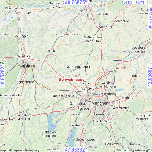
Schwabhausen GPS coordinates[2]
48° 18' 11.448" North, 11° 21' 20.664" East
| Map corner | latitude | longitude |
|---|---|---|
| Upper-left | 48.76875°, | 10.65262° |
| Center: | 48.30318°, | 11.35574° |
| Lower-right: | 47.83332°, | 12.05887° |
| Map W x H: | 104×104 km | = 64.6×64.6mi |
| max Lat: | 55.01917° ⇑91.2% North |
| Schwabhausen: | 48.30318° |
| min Lat: | ⇓8.8% South 47.40724° |
| min Long | Schwabhausen | max Long |
| 5.92978° | 11.35574° | 14.98853° |
| W 72%⇐ | ⇒28% E |
Elevation
Elevation of Schwabhausen is 487 m = 1598 ft, and this is 237.9 m = 781 ft above average elevation for this country.
| Max E: |
1256 m = 4121 ft | 12.8% |
| Schwabhausen | 487 m 1598 ft | |
| Avg. | 249.1 m = 817 ft | |
Min E: |
-5 m = -16 ft | 87.2% |
See also: Germany elevation on elevation.city.
Geographical zone
Schwabhausen is located in North temperate zone (between Tropic of Cancer and the Arctic Circle). Distance of this North polar circle is 2030.4 km =1261.6 mi to North.| Distance of | km | miles | from Schwabhausen |
|---|---|---|---|
| North Pole | 4636.3 | 2880.9 | to North |
| Arctic Circle | 2030.4 | 1261.6 | to North |
| Tropic Cancer | 2764.9 | 1718 | to South |
| Equator | 5370.8 | 3337.3 | to South |


Nearby cities:
15 places around Schwabhausen: (largest is in red/bold)
• Altomünster
11.9 km =7.4 mi,  322°
322°
• Bergkirchen
5.2 km =3.2 mi,  172°
172°
• Dachau
7.5 km =4.7 mi,  129°
129°
• Erdweg
5 km =3.1 mi,  309°
309°
• Gröbenzell
11.5 km =7.1 mi,  175°
175°
• Hebertshausen
8.2 km =5.1 mi,  100°
100°
• Maisach
11.7 km =7.3 mi,  214°
214°
• Markt Indersdorf
6.6 km =4.1 mi,  14°
14°
• Odelzhausen
11.6 km =7.2 mi,  273°
273°
• Olching
11.6 km =7.2 mi,  188°
188°
• Röhrmoos
7.3 km =4.5 mi,  66°
66°
• Schwabhausen
10.9 km =6.8 mi,  0°
0°
• Sulzemoos
7 km =4.3 mi,  258°
258°
• Vierkirchen
10.8 km =6.7 mi,  49°
49°
• Weichs
10 km =6.2 mi,  26°
26°
Sources, notices
• [Note1] Compared only with cities in Germany existing in our database
• [Src1] Map data: © OpenStreetMap contributors (CC-BY-SA)
• [Src2] Other city data from geonames.org with taken over terms of usage.
• [Src3] Geographical zone / Annual Mean Temperature by Robert A. Rohde @ Wikipedia
