Bad Harzburg geodata
Bad Harzburg (Lower Saxony) is a populated place; located in Germany in Europe/Berlin (GMT+2) time zone. With population of 22,954 people, there are 650 cities with bigger population in this country. Compared to other cities in Germany, 70.9% of cities are located further ↓South; 60% of cities are located further ←West and 55.6% of cities have lower elevation than Bad Harzburg. Note1


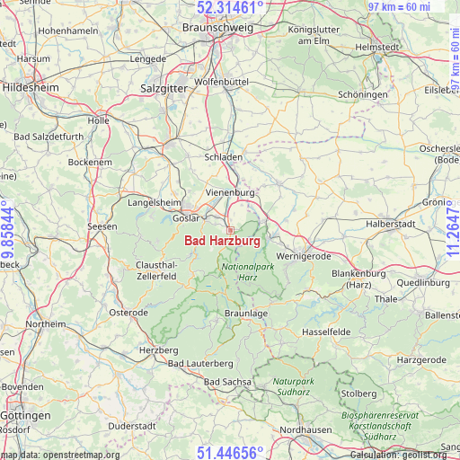
Bad Harzburg GPS coordinates[2]
51° 52' 57.648" North, 10° 33' 41.652" East
| Map corner | latitude | longitude |
|---|---|---|
| Upper-left | 52.31461°, | 9.85844° |
| Center: | 51.88268°, | 10.56157° |
| Lower-right: | 51.44656°, | 11.2647° |
| Map W x H: | 96.5×96.5 km | = 60×60mi |
| max Lat: | 55.01917° ⇑29.1% North |
| Bad Harzburg: | 51.88268° |
| min Lat: | ⇓70.9% South 47.40724° |
| min Long | Bad Harzburg | max Long |
| 5.92978° | 10.56157° | 14.98853° |
| W 60%⇐ | ⇒40% E |
Elevation
Elevation of Bad Harzburg is 262 m = 860 ft, and this is 12.9 m = 42 ft above average elevation for this country.
| Max E: |
1256 m = 4121 ft | 44.4% |
| Bad Harzburg | 262 m 860 ft | |
| Avg. | 249.1 m = 817 ft | |
Min E: |
-5 m = -16 ft | 55.6% |
See also: Germany elevation on elevation.city.
Geographical zone
Bad Harzburg is located in North temperate zone (between Tropic of Cancer and the Arctic Circle). Distance of this North polar circle is 1632.4 km =1014.3 mi to North.| Distance of | km | miles | from Bad Harzburg |
|---|---|---|---|
| North Pole | 4238.2 | 2633.5 | to North |
| Arctic Circle | 1632.4 | 1014.3 | to North |
| Tropic Cancer | 3162.9 | 1965.3 | to South |
| Equator | 5768.8 | 3584.6 | to South |


Nearby cities:
15 places around Bad Harzburg: (largest is in red/bold)
• Abbenrode
6.7 km =4.2 mi,  40°
40°
• Altenau
12.3 km =7.6 mi,  222°
222°
• Darlingerode
12.3 km =7.6 mi,  108°
108°
• Drübeck
11.1 km =6.9 mi,  104°
104°
• Goslar
9.5 km =5.9 mi,  284°
284°
• Ilsenburg
8.2 km =5.1 mi, 102°
• Lüttgenrode
11.8 km =7.3 mi, 36°
• Osterwieck
14.1 km =8.8 mi,  46°
46°
• Schierke
14.9 km =9.3 mi,  152°
152°
• Schulenberg im Oberharz
10.4 km =6.5 mi,  238°
238°
• Stapelburg
7.2 km =4.5 mi,  73°
73°
• Veckenstedt
11.9 km =7.4 mi,  80°
80°
• Vienenburg
7.8 km =4.8 mi,  1°
1°
• Wasserleben
14 km =8.7 mi, 72°
• Wülperode
11.3 km =7 mi,  13°
13°
Sources, notices
• [Note1] Compared only with cities in Germany existing in our database
• [Src1] Map data: © OpenStreetMap contributors (CC-BY-SA)
• [Src2] Other city data from geonames.org with taken over terms of usage.
• [Src3] Geographical zone / Annual Mean Temperature by Robert A. Rohde @ Wikipedia
