Roden geodata
Roden (Bavaria) is a seat of a fourth-order administrative division; located in Germany in Europe/Berlin (GMT+2) time zone. With population of 1,089 people, there are 6878 cities with bigger population in this country. Compared to other cities in Germany, 66.7% of cities are located further ↑North; 55.7% of cities are located further →East and 54.2% of cities have lower elevation than Roden. Note1
Administrative division(s):
- Level 1: Bavaria
- Level 2: Regierungsbezirk Unterfranken
- Level 3: Landkreis Main-Spessart
- Level 4: Roden


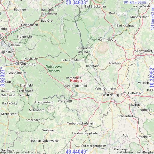
Roden GPS coordinates[2]
49° 53' 44.016" North, 9° 37' 35.004" East
| Map corner | latitude | longitude |
|---|---|---|
| Upper-left | 50.34638°, | 8.92327° |
| Center: | 49.89556°, | 9.62639° |
| Lower-right: | 49.44049°, | 10.32952° |
| Map W x H: | 100.7×100.7 km | = 62.6×62.6mi |
| max Lat: | 55.01917° ⇑66.7% North |
| Roden: | 49.89556° |
| min Lat: | ⇓33.3% South 47.40724° |
| min Long | Roden | max Long |
| 5.92978° | 9.62639° | 14.98853° |
| W 44.3%⇐ | ⇒55.7% E |
Elevation
Elevation of Roden is 253 m = 830 ft, and this is 3.9 m = 13 ft above average elevation for this country.
| Max E: |
1256 m = 4121 ft | 45.8% |
| Roden | 253 m 830 ft | |
| Avg. | 249.1 m = 817 ft | |
Min E: |
-5 m = -16 ft | 54.2% |
See also: Germany elevation on elevation.city.
Geographical zone
Roden is located in North temperate zone (between Tropic of Cancer and the Arctic Circle). Distance of this North polar circle is 1853.3 km =1151.6 mi to North.| Distance of | km | miles | from Roden |
|---|---|---|---|
| North Pole | 4459.2 | 2770.8 | to North |
| Arctic Circle | 1853.3 | 1151.6 | to North |
| Tropic Cancer | 2941.9 | 1828 | to South |
| Equator | 5547.9 | 3447.3 | to South |


Nearby cities:
15 places around Roden: (largest is in red/bold)
• Birkenfeld
6.4 km =4 mi,  129°
129°
• Bischbrunn
10.2 km =6.3 mi,  254°
254°
• Erlenbach
9.3 km =5.8 mi,  8°
8°
• Esselbach
8.5 km =5.3 mi,  238°
238°
• Hafenlohr
3.4 km =2.1 mi,  210°
210°
• Himmelstadt
12.9 km =8 mi,  75°
75°
• Karbach
3.3 km =2.1 mi,  165°
165°
• Karlstadt
12.7 km =7.9 mi,  55°
55°
• Lohr am Main
11.1 km =6.9 mi,  339°
339°
• Marktheidenfeld
5.8 km =3.6 mi,  196°
196°
• Neustadt am Main
5.7 km =3.5 mi,  312°
312°
• Remlingen
11.2 km =7 mi,  154°
154°
• Rothenfels
2.5 km =1.6 mi,  259°
259°
• Steinfeld
7.1 km =4.4 mi,  25°
25°
• Urspringen
3.3 km =2.1 mi, 78°
Sources, notices
• [Note1] Compared only with cities in Germany existing in our database
• [Src1] Map data: © OpenStreetMap contributors (CC-BY-SA)
• [Src2] Other city data from geonames.org with taken over terms of usage.
• [Src3] Geographical zone / Annual Mean Temperature by Robert A. Rohde @ Wikipedia
