Rothenfels geodata
Rothenfels (Bavaria) is a populated place; located in Germany in Europe/Berlin (GMT+2) time zone. With population of 1,088 people, there are 6886 cities with bigger population in this country. Compared to other cities in Germany, 66.7% of cities are located further ↑North; 56.3% of cities are located further →East and 60% of cities have higher elevation than Rothenfels. Note1
Administrative division(s):
- Level 1: Bavaria
- Level 2: Regierungsbezirk Unterfranken
- Level 3: Landkreis Main-Spessart
- Level 4: Rothenfels


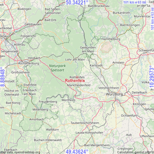
Rothenfels GPS coordinates[2]
49° 53' 28.86" North, 9° 35' 33.36" East
| Map corner | latitude | longitude |
|---|---|---|
| Upper-left | 50.34221°, | 8.88948° |
| Center: | 49.89135°, | 9.5926° |
| Lower-right: | 49.43624°, | 10.29573° |
| Map W x H: | 100.7×100.7 km | = 62.6×62.6mi |
| max Lat: | 55.01917° ⇑66.7% North |
| Rothenfels: | 49.89135° |
| min Lat: | ⇓33.3% South 47.40724° |
| min Long | Rothenfels | max Long |
| 5.92978° | 9.5926° | 14.98853° |
| W 43.7%⇐ | ⇒56.3% E |
Elevation
Elevation of Rothenfels is 152 m = 499 ft, and this is 97.1 m = 319 ft below average elevation for this country.
| Max E: |
1256 m = 4121 ft | 60% |
| Avg. | 249.1 m = 817 ft | |
| Rothenfels | 152 m = 499 ft | |
Min E: |
-5 m = -16 ft | 40% |
See also: Germany elevation on elevation.city.
Geographical zone
Rothenfels is located in North temperate zone (between Tropic of Cancer and the Arctic Circle). Distance of this North polar circle is 1853.8 km =1151.9 mi to North.| Distance of | km | miles | from Rothenfels |
|---|---|---|---|
| North Pole | 4459.7 | 2771.1 | to North |
| Arctic Circle | 1853.8 | 1151.9 | to North |
| Tropic Cancer | 2941.5 | 1827.8 | to South |
| Equator | 5547.4 | 3447 | to South |


Nearby cities:
15 places around Rothenfels: (largest is in red/bold)
• Birkenfeld
8.2 km =5.1 mi,  116°
116°
• Bischbrunn
7.8 km =4.8 mi,  252°
252°
• Erlenbach
10.4 km =6.5 mi,  20°
20°
• Esselbach
6.2 km =3.9 mi,  230°
230°
• Hafenlohr
2.5 km =1.6 mi,  164°
164°
• Karbach
4.2 km =2.6 mi,  129°
129°
• Lohr am Main
11 km =6.8 mi,  352°
352°
• Marktheidenfeld
5.2 km =3.2 mi,  171°
171°
• Neustadt am Main
4.7 km =2.9 mi,  337°
337°
• Rechtenbach
11.8 km =7.3 mi,  329°
329°
• Remlingen
12.1 km =7.5 mi,  142°
142°
• Roden
2.5 km =1.6 mi,  79°
79°
• Schollbrunn
11.2 km =7 mi,  235°
235°
• Steinfeld
8.8 km =5.5 mi,  38°
38°
• Urspringen
5.7 km =3.5 mi, 78°
Sources, notices
• [Note1] Compared only with cities in Germany existing in our database
• [Src1] Map data: © OpenStreetMap contributors (CC-BY-SA)
• [Src2] Other city data from geonames.org with taken over terms of usage.
• [Src3] Geographical zone / Annual Mean Temperature by Robert A. Rohde @ Wikipedia
