Tschernitz geodata
Tschernitz (Brandenburg) is a seat of a fourth-order administrative division; located in Germany in Europe/Berlin (GMT+2) time zone. With population of 1,630 people, there are 5636 cities with bigger population in this country. Compared to other cities in Germany, 67.3% of cities are located further ↓South; 99.6% of cities are located further ←West and 62.5% of cities have higher elevation than Tschernitz. Note1


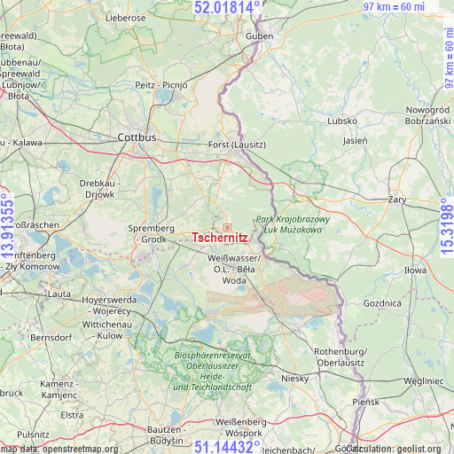
Tschernitz GPS coordinates[2]
51° 34' 59.988" North, 14° 37' 0.012" East
| Map corner | latitude | longitude |
|---|---|---|
| Upper-left | 52.01814°, | 13.91355° |
| Center: | 51.58333°, | 14.61667° |
| Lower-right: | 51.14432°, | 15.3198° |
| Map W x H: | 97.2×97.2 km | = 60.4×60.4mi |
| max Lat: | 55.01917° ⇑32.7% North |
| Tschernitz: | 51.58333° |
| min Lat: | ⇓67.3% South 47.40724° |
| min Long | Tschernitz | max Long |
| 5.92978° | 14.61667° | 14.98853° |
| W 99.6%⇐ | ⇒0.40000000000001% E |
Elevation
Elevation of Tschernitz is 135 m = 443 ft, and this is 114.1 m = 374 ft below average elevation for this country.
| Max E: |
1256 m = 4121 ft | 62.5% |
| Avg. | 249.1 m = 817 ft | |
| Tschernitz | 135 m = 443 ft | |
Min E: |
-5 m = -16 ft | 37.5% |
See also: Germany elevation on elevation.city.
Geographical zone
Tschernitz is located in North temperate zone (between Tropic of Cancer and the Arctic Circle). Distance of this North polar circle is 1665.6 km =1035 mi to North.| Distance of | km | miles | from Tschernitz |
|---|---|---|---|
| North Pole | 4271.5 | 2654.2 | to North |
| Arctic Circle | 1665.6 | 1035 | to North |
| Tropic Cancer | 3129.6 | 1944.6 | to South |
| Equator | 5735.5 | 3563.9 | to South |


Nearby cities:
15 places around Tschernitz: (largest is in red/bold)
• Bad Muskau
7.6 km =4.7 mi,  118°
118°
• Boxberg
20.2 km =12.6 mi,  188°
188°
• Forst
17 km =10.6 mi,  5°
5°
• Gablenz
6.5 km =4 mi,  148°
148°
• Groß Döbbern
21.2 km =13.2 mi,  290°
290°
• Groß Düben
3.9 km =2.4 mi,  241°
241°
• Groß Oßnig
20.7 km =12.9 mi,  300°
300°
• Komptendorf
15 km =9.3 mi,  318°
318°
• Krauschwitz
9.5 km =5.9 mi,  136°
136°
• Laubsdorf
15.7 km =9.8 mi,  310°
310°
• Schleife
8 km =5 mi,  226°
226°
• Spremberg
16.8 km =10.4 mi,  264°
264°
• Trebendorf
6.5 km =4 mi,  211°
211°
• Weißkeißel
12 km =7.5 mi, 145°
• Weißwasser
9 km =5.6 mi,  169°
169°
Sources, notices
• [Note1] Compared only with cities in Germany existing in our database
• [Src1] Map data: © OpenStreetMap contributors (CC-BY-SA)
• [Src2] Other city data from geonames.org with taken over terms of usage.
• [Src3] Geographical zone / Annual Mean Temperature by Robert A. Rohde @ Wikipedia
