Weißkeißel geodata
Weißkeißel (Saxony) is a seat of a fourth-order administrative division; located in Germany in Europe/Berlin (GMT+2) time zone. With population of 1,481 people, there are 5918 cities with bigger population in this country. Compared to other cities in Germany, 66.2% of cities are located further ↓South; 99.8% of cities are located further ←West and 64.5% of cities have higher elevation than Weißkeißel. Note1


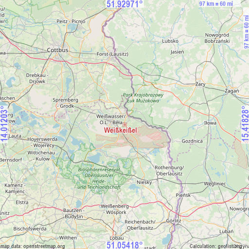
Weißkeißel GPS coordinates[2]
51° 29' 38.58" North, 14° 42' 54.54" East
| Map corner | latitude | longitude |
|---|---|---|
| Upper-left | 51.92971°, | 14.01203° |
| Center: | 51.49405°, | 14.71515° |
| Lower-right: | 51.05418°, | 15.41828° |
| Map W x H: | 97.3×97.3 km | = 60.5×60.5mi |
| max Lat: | 55.01917° ⇑33.8% North |
| Weißkeißel: | 51.49405° |
| min Lat: | ⇓66.2% South 47.40724° |
| min Long | Weißkeißel | max Long |
| 5.92978° | 14.71515° | 14.98853° |
| W 99.8%⇐ | ⇒0.2% E |
Elevation
Elevation of Weißkeißel is 124 m = 407 ft, and this is 125.1 m = 410 ft below average elevation for this country.
| Max E: |
1256 m = 4121 ft | 64.5% |
| Avg. | 249.1 m = 817 ft | |
| Weißkeißel | 124 m = 407 ft | |
Min E: |
-5 m = -16 ft | 35.5% |
See also: Germany elevation on elevation.city.
Geographical zone
Weißkeißel is located in North temperate zone (between Tropic of Cancer and the Arctic Circle). Distance of this North polar circle is 1675.6 km =1041.2 mi to North.| Distance of | km | miles | from Weißkeißel |
|---|---|---|---|
| North Pole | 4281.5 | 2660.4 | to North |
| Arctic Circle | 1675.6 | 1041.2 | to North |
| Tropic Cancer | 3119.7 | 1938.5 | to South |
| Equator | 5725.6 | 3557.7 | to South |


Nearby cities:
15 places around Weißkeißel: (largest is in red/bold)
• Bad Muskau
6.3 km =3.9 mi,  358°
358°
• Boxberg
13.9 km =8.6 mi,  223°
223°
• Gablenz
5.5 km =3.4 mi,  322°
322°
• Groß Düben
13.1 km =8.1 mi,  308°
308°
• Hähnichen
17.5 km =10.9 mi,  144°
144°
• Klitten
17.6 km =10.9 mi,  205°
205°
• Krauschwitz
3.1 km =1.9 mi, 356°
• Mücka
19.8 km =12.3 mi,  183°
183°
• Niesky
23.6 km =14.7 mi,  161°
161°
• Rietschen
11.5 km =7.1 mi, 155°
• Schleife
13.3 km =8.3 mi,  289°
289°
• Trebendorf
11.2 km =7 mi, 293°
• Tschernitz
12 km =7.5 mi,  325°
325°
• Uhyst
20.4 km =12.7 mi,  225°
225°
• Weißwasser
5.3 km =3.3 mi,  282°
282°
Sources, notices
• [Note1] Compared only with cities in Germany existing in our database
• [Src1] Map data: © OpenStreetMap contributors (CC-BY-SA)
• [Src2] Other city data from geonames.org with taken over terms of usage.
• [Src3] Geographical zone / Annual Mean Temperature by Robert A. Rohde @ Wikipedia
