Forst geodata
Forst (Brandenburg) is a seat of a third-order administrative division; located in Germany in Europe/Berlin (GMT+2) time zone. With population of 22,843 people, there are 653 cities with bigger population in this country. Compared to other cities in Germany, 69.2% of cities are located further ↓South; 99.6% of cities are located further ←West and 71.7% of cities have higher elevation than Forst. Note1
Administrative division(s):
- Level 1: Brandenburg
- Level 3: Landkreis Spree-Neiße
- Level 4: Forst (Lausitz)


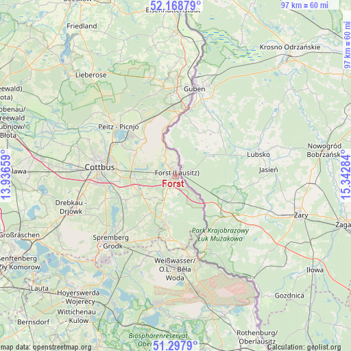
Forst GPS coordinates[2]
51° 44' 7.584" North, 14° 38' 22.956" East
| Map corner | latitude | longitude |
|---|---|---|
| Upper-left | 52.16879°, | 13.93659° |
| Center: | 51.73544°, | 14.63971° |
| Lower-right: | 51.2979°, | 15.34284° |
| Map W x H: | 96.8×96.8 km | = 60.1×60.1mi |
| max Lat: | 55.01917° ⇑30.8% North |
| Forst: | 51.73544° |
| min Lat: | ⇓69.2% South 47.40724° |
| min Long | Forst | max Long |
| 5.92978° | 14.63971° | 14.98853° |
| W 99.6%⇐ | ⇒0.40000000000001% E |
Elevation
Elevation of Forst is 80 m = 262 ft, and this is 169.1 m = 555 ft below average elevation for this country.
| Max E: |
1256 m = 4121 ft | 71.7% |
| Avg. | 249.1 m = 817 ft | |
| Forst | 80 m = 262 ft | |
Min E: |
-5 m = -16 ft | 28.3% |
See also: Germany elevation on elevation.city.
Geographical zone
Forst is located in North temperate zone (between Tropic of Cancer and the Arctic Circle). Distance of this North polar circle is 1648.7 km =1024.5 mi to North.| Distance of | km | miles | from Forst |
|---|---|---|---|
| North Pole | 4254.6 | 2643.7 | to North |
| Arctic Circle | 1648.7 | 1024.5 | to North |
| Tropic Cancer | 3146.5 | 1955.1 | to South |
| Equator | 5752.4 | 3574.4 | to South |


Nearby cities:
15 places around Forst: (largest is in red/bold)
• Bad Muskau
21.2 km =13.2 mi,  166°
166°
• Cottbus
21.5 km =13.4 mi,  276°
276°
• Gablenz
22.5 km =14 mi,  175°
175°
• Groß Döbbern
23.3 km =14.5 mi,  246°
246°
• Groß Düben
19.4 km =12.1 mi,  195°
195°
• Groß Oßnig
20.3 km =12.6 mi, 251°
• Heinersbrück
13.1 km =8.1 mi,  315°
315°
• Jänschwalde
17 km =10.6 mi,  325°
325°
• Komptendorf
12.8 km =8 mi,  243°
243°
• Laubsdorf
15.2 km =9.4 mi, 243°
• Peitz
20.8 km =12.9 mi,  311°
311°
• Schleife
23.6 km =14.7 mi, 198°
• Tauer
22.5 km =14 mi, 324°
• Trebendorf
23 km =14.3 mi,  192°
192°
• Tschernitz
17 km =10.6 mi, 185°
Sources, notices
• [Note1] Compared only with cities in Germany existing in our database
• [Src1] Map data: © OpenStreetMap contributors (CC-BY-SA)
• [Src2] Other city data from geonames.org with taken over terms of usage.
• [Src3] Geographical zone / Annual Mean Temperature by Robert A. Rohde @ Wikipedia
