Gablenz geodata
Gablenz (Saxony) is a seat of a fourth-order administrative division; located in Germany in Europe/Berlin (GMT+2) time zone. With population of 1,950 people, there are 5136 cities with bigger population in this country. Compared to other cities in Germany, 66.7% of cities are located further ↓South; 99.7% of cities are located further ←West and 61.5% of cities have higher elevation than Gablenz. Note1


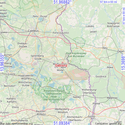
Gablenz GPS coordinates[2]
51° 31' 59.988" North, 14° 40' 0.012" East
| Map corner | latitude | longitude |
|---|---|---|
| Upper-left | 51.96862°, | 13.96355° |
| Center: | 51.53333°, | 14.66667° |
| Lower-right: | 51.09384°, | 15.3698° |
| Map W x H: | 97.3×97.3 km | = 60.5×60.5mi |
| max Lat: | 55.01917° ⇑33.3% North |
| Gablenz: | 51.53333° |
| min Lat: | ⇓66.7% South 47.40724° |
| min Long | Gablenz | max Long |
| 5.92978° | 14.66667° | 14.98853° |
| W 99.7%⇐ | ⇒0.3% E |
Elevation
Elevation of Gablenz is 142 m = 466 ft, and this is 107.1 m = 351 ft below average elevation for this country.
| Max E: |
1256 m = 4121 ft | 61.5% |
| Avg. | 249.1 m = 817 ft | |
| Gablenz | 142 m = 466 ft | |
Min E: |
-5 m = -16 ft | 38.5% |
See also: Germany elevation on elevation.city.
Geographical zone
Gablenz is located in North temperate zone (between Tropic of Cancer and the Arctic Circle). Distance of this North polar circle is 1671.2 km =1038.4 mi to North.| Distance of | km | miles | from Gablenz |
|---|---|---|---|
| North Pole | 4277.1 | 2657.7 | to North |
| Arctic Circle | 1671.2 | 1038.4 | to North |
| Tropic Cancer | 3124.1 | 1941.2 | to South |
| Equator | 5730 | 3560.5 | to South |


Nearby cities:
15 places around Gablenz: (largest is in red/bold)
• Bad Muskau
3.7 km =2.3 mi,  58°
58°
• Boxberg
15.7 km =9.8 mi,  203°
203°
• Groß Düben
7.8 km =4.8 mi,  298°
298°
• Klitten
20.7 km =12.9 mi,  191°
191°
• Komptendorf
21.5 km =13.4 mi,  321°
321°
• Krauschwitz
3.4 km =2.1 mi,  112°
112°
• Laubsdorf
22.1 km =13.7 mi, 315°
• Rietschen
16.9 km =10.5 mi,  151°
151°
• Schleife
9.2 km =5.7 mi,  270°
270°
• Spremberg
20.6 km =12.8 mi,  281°
281°
• Trebendorf
6.9 km =4.3 mi, 270°
• Tschernitz
6.5 km =4 mi,  328°
328°
• Uhyst
21.8 km =13.5 mi,  210°
210°
• Weißkeißel
5.5 km =3.4 mi,  142°
142°
• Weißwasser
3.7 km =2.3 mi, 209°
Sources, notices
• [Note1] Compared only with cities in Germany existing in our database
• [Src1] Map data: © OpenStreetMap contributors (CC-BY-SA)
• [Src2] Other city data from geonames.org with taken over terms of usage.
• [Src3] Geographical zone / Annual Mean Temperature by Robert A. Rohde @ Wikipedia
