Jengen geodata
Jengen (Bavaria) is a seat of a fourth-order administrative division; located in Germany in Europe/Berlin (GMT+2) time zone. With population of 2,433 people, there are 4524 cities with bigger population in this country. Compared to other cities in Germany, 95.6% of cities are located further ↑North; 62.9% of cities are located further ←West and 96.3% of cities have lower elevation than Jengen. Note1
Administrative division(s):
- Level 1: Bavaria
- Level 2: Swabia
- Level 3: Landkreis Ostallgäu
- Level 4: Jengen


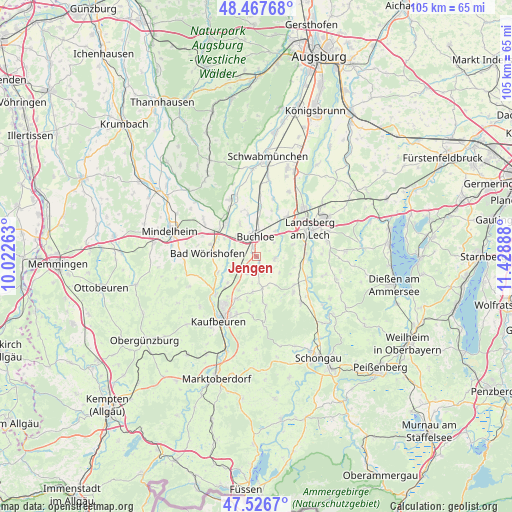
Jengen GPS coordinates[2]
47° 59' 57.624" North, 10° 43' 32.7" East
| Map corner | latitude | longitude |
|---|---|---|
| Upper-left | 48.46768°, | 10.02263° |
| Center: | 47.99934°, | 10.72575° |
| Lower-right: | 47.5267°, | 11.42888° |
| Map W x H: | 104.6×104.6 km | = 65×65mi |
| max Lat: | 55.01917° ⇑95.6% North |
| Jengen: | 47.99934° |
| min Lat: | ⇓4.4% South 47.40724° |
| min Long | Jengen | max Long |
| 5.92978° | 10.72575° | 14.98853° |
| W 62.9%⇐ | ⇒37.1% E |
Elevation
Elevation of Jengen is 637 m = 2090 ft, and this is 387.9 m = 1273 ft above average elevation for this country.
| Max E: |
1256 m = 4121 ft | 3.7% |
| Jengen | 637 m 2090 ft | |
| Avg. | 249.1 m = 817 ft | |
Min E: |
-5 m = -16 ft | 96.3% |
See also: Germany elevation on elevation.city.
Geographical zone
Jengen is located in North temperate zone (between Tropic of Cancer and the Arctic Circle). Distance of this North polar circle is 2064.1 km =1282.6 mi to North.| Distance of | km | miles | from Jengen |
|---|---|---|---|
| North Pole | 4670 | 2901.8 | to North |
| Arctic Circle | 2064.1 | 1282.6 | to North |
| Tropic Cancer | 2731.1 | 1697 | to South |
| Equator | 5337 | 3316.3 | to South |


Nearby cities:
15 places around Jengen: (largest is in red/bold)
• Amberg
8.1 km =5 mi,  337°
337°
• Bad Wörishofen
9.6 km =6 mi,  274°
274°
• Buchloe
4.2 km =2.6 mi,  359°
359°
• Ettringen
12.5 km =7.8 mi,  333°
333°
• Lamerdingen
10.4 km =6.5 mi,  5°
5°
• Landsberg am Lech
12.9 km =8 mi,  65°
65°
• Mauerstetten
12.4 km =7.7 mi,  199°
199°
• Oberostendorf
6.3 km =3.9 mi,  168°
168°
• Pforzen
11.4 km =7.1 mi,  227°
227°
• Rieden
7.9 km =4.9 mi, 225°
• Türkheim
9.5 km =5.9 mi,  318°
318°
• Unterdießen
8.2 km =5.1 mi,  102°
102°
• Waal
3.9 km =2.4 mi,  94°
94°
• Westendorf
7.4 km =4.6 mi,  185°
185°
• Wiedergeltingen
5.9 km =3.7 mi, 319°
Sources, notices
• [Note1] Compared only with cities in Germany existing in our database
• [Src1] Map data: © OpenStreetMap contributors (CC-BY-SA)
• [Src2] Other city data from geonames.org with taken over terms of usage.
• [Src3] Geographical zone / Annual Mean Temperature by Robert A. Rohde @ Wikipedia
