Dirlewang geodata
Dirlewang (Bavaria) is a populated place; located in Germany in Europe/Berlin (GMT+2) time zone. With population of 2,148 people, there are 4874 cities with bigger population in this country. Compared to other cities in Germany, 95.5% of cities are located further ↑North; 59% of cities are located further ←West and 96% of cities have lower elevation than Dirlewang. Note1
Administrative division(s):
- Level 1: Bavaria
- Level 2: Swabia
- Level 3: Landkreis Unterallgäu
- Level 4: Dirlewang, Markt


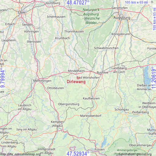
Dirlewang GPS coordinates[2]
48° 0' 7.02" North, 10° 30' 11.016" East
| Map corner | latitude | longitude |
|---|---|---|
| Upper-left | 48.47027°, | 9.79994° |
| Center: | 48.00195°, | 10.50306° |
| Lower-right: | 47.52934°, | 11.20619° |
| Map W x H: | 104.6×104.6 km | = 65×65mi |
| max Lat: | 55.01917° ⇑95.5% North |
| Dirlewang: | 48.00195° |
| min Lat: | ⇓4.5% South 47.40724° |
| min Long | Dirlewang | max Long |
| 5.92978° | 10.50306° | 14.98853° |
| W 59%⇐ | ⇒41% E |
Elevation
Elevation of Dirlewang is 626 m = 2054 ft, and this is 376.9 m = 1237 ft above average elevation for this country.
| Max E: |
1256 m = 4121 ft | 4% |
| Dirlewang | 626 m 2054 ft | |
| Avg. | 249.1 m = 817 ft | |
Min E: |
-5 m = -16 ft | 96% |
See also: Germany elevation on elevation.city.
Geographical zone
Dirlewang is located in North temperate zone (between Tropic of Cancer and the Arctic Circle). Distance of this North polar circle is 2063.9 km =1282.4 mi to North.| Distance of | km | miles | from Dirlewang |
|---|---|---|---|
| North Pole | 4669.7 | 2901.6 | to North |
| Arctic Circle | 2063.9 | 1282.4 | to North |
| Tropic Cancer | 2731.4 | 1697.2 | to South |
| Equator | 5337.3 | 3316.4 | to South |


Nearby cities:
15 places around Dirlewang: (largest is in red/bold)
• Apfeltrach
1.7 km =1.1 mi,  352°
352°
• Bad Wörishofen
7 km =4.3 mi,  85°
85°
• Baisweil
7 km =4.3 mi,  156°
156°
• Eggenthal
9.5 km =5.9 mi,  173°
173°
• Irsee
11.6 km =7.2 mi,  153°
153°
• Markt Rettenbach
10 km =6.2 mi,  232°
232°
• Mindelheim
4.9 km =3 mi, 350°
• Oberrieden
11.2 km =7 mi,  329°
329°
• Pforzen
11.5 km =7.1 mi,  134°
134°
• Rieden
12.4 km =7.7 mi,  117°
117°
• Sontheim
11.1 km =6.9 mi,  272°
272°
• Stetten
5 km =3.1 mi,  299°
299°
• Tussenhausen
11.9 km =7.4 mi,  21°
21°
• Türkheim
12.4 km =7.7 mi,  56°
56°
• Unteregg
4.8 km =3 mi,  214°
214°
Sources, notices
• [Note1] Compared only with cities in Germany existing in our database
• [Src1] Map data: © OpenStreetMap contributors (CC-BY-SA)
• [Src2] Other city data from geonames.org with taken over terms of usage.
• [Src3] Geographical zone / Annual Mean Temperature by Robert A. Rohde @ Wikipedia
