Torgau geodata
Torgau (Saxony) is a seat of a third-order administrative division; located in Germany in Europe/Berlin (GMT+2) time zone. With population of 18,746 people, there are 835 cities with bigger population in this country. Compared to other cities in Germany, 67% of cities are located further ↓South; 92.3% of cities are located further ←West and 70.4% of cities have higher elevation than Torgau. Note1


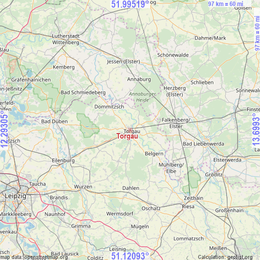
Torgau GPS coordinates[2]
51° 33' 36.576" North, 12° 59' 46.212" East
| Map corner | latitude | longitude |
|---|---|---|
| Upper-left | 51.99519°, | 12.29305° |
| Center: | 51.56016°, | 12.99617° |
| Lower-right: | 51.12093°, | 13.6993° |
| Map W x H: | 97.2×97.2 km | = 60.4×60.4mi |
| max Lat: | 55.01917° ⇑33% North |
| Torgau: | 51.56016° |
| min Lat: | ⇓67% South 47.40724° |
| min Long | Torgau | max Long |
| 5.92978° | 12.99617° | 14.98853° |
| W 92.3%⇐ | ⇒7.7% E |
Elevation
Elevation of Torgau is 89 m = 292 ft, and this is 160.1 m = 525 ft below average elevation for this country.
| Max E: |
1256 m = 4121 ft | 70.4% |
| Avg. | 249.1 m = 817 ft | |
| Torgau | 89 m = 292 ft | |
Min E: |
-5 m = -16 ft | 29.6% |
See also: Germany elevation on elevation.city.
Geographical zone
Torgau is located in North temperate zone (between Tropic of Cancer and the Arctic Circle). Distance of this North polar circle is 1668.2 km =1036.6 mi to North.| Distance of | km | miles | from Torgau |
|---|---|---|---|
| North Pole | 4274.1 | 2655.8 | to North |
| Arctic Circle | 1668.2 | 1036.6 | to North |
| Tropic Cancer | 3127 | 1943 | to South |
| Equator | 5733 | 3562.3 | to South |


Nearby cities:
15 places around Torgau: (largest is in red/bold)
• Annaburg
19.5 km =12.1 mi,  10°
10°
• Arzberg
9.6 km =6 mi,  111°
111°
• Axien
17.4 km =10.8 mi,  334°
334°
• Beilrode
4.9 km =3 mi,  81°
81°
• Belgern
12.3 km =7.6 mi,  134°
134°
• Doberschütz
18.5 km =11.5 mi,  248°
248°
• Dommitzsch
12.1 km =7.5 mi,  317°
317°
• Elsnig
7.3 km =4.5 mi, 319°
• Falkenberg
17.3 km =10.7 mi, 80°
• Falkenhain
19.9 km =12.4 mi,  205°
205°
• Mockrehna
13.9 km =8.6 mi, 245°
• Prettin
12.3 km =7.6 mi,  335°
335°
• Schildau
12.3 km =7.6 mi,  201°
201°
• Trossin
13.9 km =8.6 mi,  296°
296°
• Zinna
3.1 km =1.9 mi,  286°
286°
Sources, notices
• [Note1] Compared only with cities in Germany existing in our database
• [Src1] Map data: © OpenStreetMap contributors (CC-BY-SA)
• [Src2] Other city data from geonames.org with taken over terms of usage.
• [Src3] Geographical zone / Annual Mean Temperature by Robert A. Rohde @ Wikipedia
