Falkenhain geodata
Falkenhain (Saxony) is a populated place; located in Germany in Europe/Berlin (GMT+2) time zone. With population of 3,987 people, there are 3308 cities with bigger population in this country. Compared to other cities in Germany, 64.7% of cities are located further ↓South; 91.2% of cities are located further ←West and 62.5% of cities have higher elevation than Falkenhain. Note1


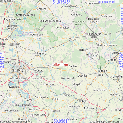
Falkenhain GPS coordinates[2]
51° 23' 55.968" North, 12° 52' 14.988" East
| Map corner | latitude | longitude |
|---|---|---|
| Upper-left | 51.83545°, | 12.16771° |
| Center: | 51.39888°, | 12.87083° |
| Lower-right: | 50.9581°, | 13.57396° |
| Map W x H: | 97.6×97.6 km | = 60.6×60.6mi |
| max Lat: | 55.01917° ⇑35.3% North |
| Falkenhain: | 51.39888° |
| min Lat: | ⇓64.7% South 47.40724° |
| min Long | Falkenhain | max Long |
| 5.92978° | 12.87083° | 14.98853° |
| W 91.2%⇐ | ⇒8.8% E |
Elevation
Elevation of Falkenhain is 135 m = 443 ft, and this is 114.1 m = 374 ft below average elevation for this country.
| Max E: |
1256 m = 4121 ft | 62.5% |
| Avg. | 249.1 m = 817 ft | |
| Falkenhain | 135 m = 443 ft | |
Min E: |
-5 m = -16 ft | 37.5% |
See also: Germany elevation on elevation.city.
Geographical zone
Falkenhain is located in North temperate zone (between Tropic of Cancer and the Arctic Circle). Distance of this North polar circle is 1686.2 km =1047.8 mi to North.| Distance of | km | miles | from Falkenhain |
|---|---|---|---|
| North Pole | 4292 | 2666.9 | to North |
| Arctic Circle | 1686.2 | 1047.8 | to North |
| Tropic Cancer | 3109.1 | 1931.9 | to South |
| Equator | 5715 | 3551.1 | to South |


Nearby cities:
15 places around Falkenhain: (largest is in red/bold)
• Bennewitz
11.7 km =7.3 mi,  248°
248°
• Cavertitz
18.3 km =11.4 mi,  95°
95°
• Dahlen
9.6 km =6 mi,  113°
113°
• Doberschütz
14 km =8.7 mi,  322°
322°
• Eilenburg
17.8 km =11.1 mi,  292°
292°
• Hohburg
4.8 km =3 mi, 287°
• Machern
16.9 km =10.5 mi,  257°
257°
• Mockrehna
12.7 km =7.9 mi,  342°
342°
• Mutzschen
15.3 km =9.5 mi,  174°
174°
• Nerchau
15.3 km =9.5 mi,  201°
201°
• Schildau
7.7 km =4.8 mi,  32°
32°
• Thallwitz
13.6 km =8.5 mi, 286°
• Trebsen
14.6 km =9.1 mi,  213°
213°
• Wermsdorf
14 km =8.7 mi,  156°
156°
• Wurzen
9.6 km =6 mi, 251°
Sources, notices
• [Note1] Compared only with cities in Germany existing in our database
• [Src1] Map data: © OpenStreetMap contributors (CC-BY-SA)
• [Src2] Other city data from geonames.org with taken over terms of usage.
• [Src3] Geographical zone / Annual Mean Temperature by Robert A. Rohde @ Wikipedia
