Belgern geodata
Belgern (Saxony) is a populated place; located in Germany in Europe/Berlin (GMT+2) time zone. With population of 5,148 people, there are 2771 cities with bigger population in this country. Compared to other cities in Germany, 66.1% of cities are located further ↓South; 93.2% of cities are located further ←West and 66.2% of cities have higher elevation than Belgern. Note1
Administrative division(s):
- Level 1: Saxony
- Level 3: Landkreis Nordsachsen
- Level 4: Belgern-Schildau


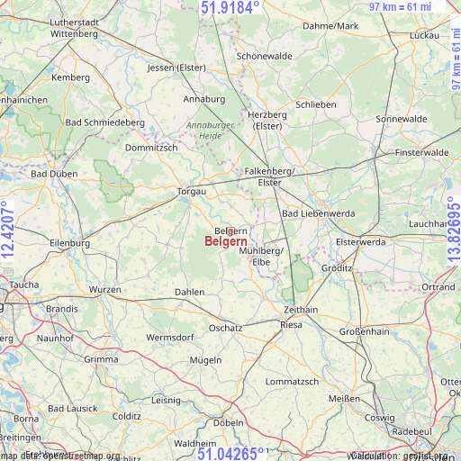
Belgern GPS coordinates[2]
51° 28' 57.468" North, 13° 7' 25.752" East
| Map corner | latitude | longitude |
|---|---|---|
| Upper-left | 51.9184°, | 12.4207° |
| Center: | 51.48263°, | 13.12382° |
| Lower-right: | 51.04265°, | 13.82695° |
| Map W x H: | 97.4×97.4 km | = 60.5×60.5mi |
| max Lat: | 55.01917° ⇑33.9% North |
| Belgern: | 51.48263° |
| min Lat: | ⇓66.1% South 47.40724° |
| min Long | Belgern | max Long |
| 5.92978° | 13.12382° | 14.98853° |
| W 93.2%⇐ | ⇒6.8% E |
Elevation
Elevation of Belgern is 113 m = 371 ft, and this is 136.1 m = 447 ft below average elevation for this country.
| Max E: |
1256 m = 4121 ft | 66.2% |
| Avg. | 249.1 m = 817 ft | |
| Belgern | 113 m = 371 ft | |
Min E: |
-5 m = -16 ft | 33.8% |
See also: Germany elevation on elevation.city.
Geographical zone
Belgern is located in North temperate zone (between Tropic of Cancer and the Arctic Circle). Distance of this North polar circle is 1676.8 km =1041.9 mi to North.| Distance of | km | miles | from Belgern |
|---|---|---|---|
| North Pole | 4282.7 | 2661.1 | to North |
| Arctic Circle | 1676.8 | 1041.9 | to North |
| Tropic Cancer | 3118.4 | 1937.7 | to South |
| Equator | 5724.3 | 3556.9 | to South |


Nearby cities:
15 places around Belgern: (largest is in red/bold)
• Arzberg
5.1 km =3.2 mi,  1°
1°
• Bad Liebenwerda
19.2 km =11.9 mi,  78°
78°
• Beilrode
10.1 km =6.3 mi,  337°
337°
• Cavertitz
11.1 km =6.9 mi,  176°
176°
• Dahlen
15.7 km =9.8 mi,  213°
213°
• Elsnig
19.6 km =12.2 mi,  316°
316°
• Falkenberg
14.1 km =8.8 mi,  35°
35°
• Falkenhain
19.9 km =12.4 mi,  242°
242°
• Mühlberg
8.6 km =5.3 mi,  128°
128°
• Oschatz
20.3 km =12.6 mi, 182°
• Schildau
13.7 km =8.5 mi,  258°
258°
• Strehla
16.1 km =10 mi,  153°
153°
• Torgau
12.3 km =7.6 mi,  314°
314°
• Uebigau
17.4 km =10.8 mi, 44°
• Zinna
15.1 km =9.4 mi, 308°
Sources, notices
• [Note1] Compared only with cities in Germany existing in our database
• [Src1] Map data: © OpenStreetMap contributors (CC-BY-SA)
• [Src2] Other city data from geonames.org with taken over terms of usage.
• [Src3] Geographical zone / Annual Mean Temperature by Robert A. Rohde @ Wikipedia
